You are here: Home > Network List > TA - USArray Transportable Network (new EarthScope stations) Stations List
> Station I21K Tanana, AK, USA > Earthquake Result Viewer
I21K Tanana, AK, USA - Earthquake Result Viewer
| Earthquake location: |
New Ireland Region, P.N.G. |
| Earthquake latitude/longitude: |
-4.8/153.2 |
| Earthquake time(UTC): |
2017/07/13 (194) 03:36:09 GMT |
| Earthquake Depth: |
47 km |
| Earthquake Magnitude: |
6.4 mww |
| Earthquake Catalog/Contributor: |
NEIC PDE/us |
|
| Network: |
TA USArray Transportable Network (new EarthScope stations) |
| Station: |
I21K Tanana, AK, USA |
| Lat/Lon: |
65.18 N/151.98 W |
| Elevation: |
248 m |
|
| Distance: |
80.4 deg |
| Az: |
20.492 deg |
| Baz: |
235.742 deg |
| Ray Param: |
0.04822941 |
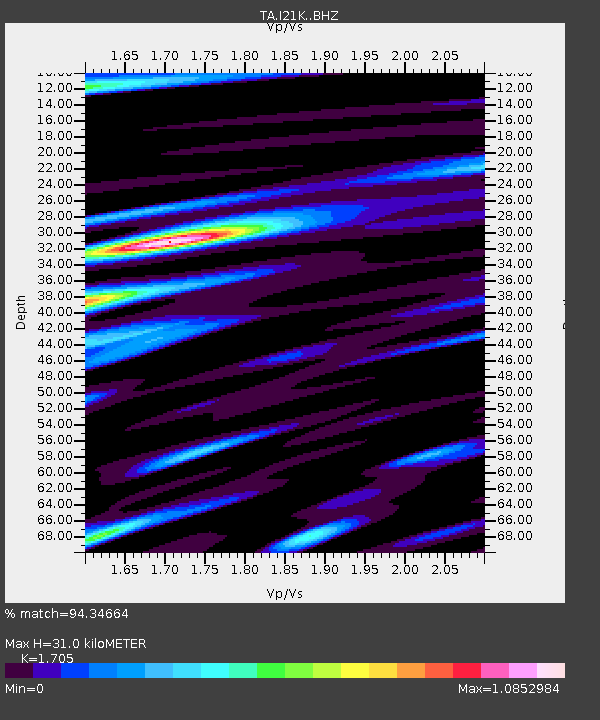
| Estimated Moho Depth: |
31.0 km |
| Estimated Crust Vp/Vs: |
1.71 |
| Assumed Crust Vp: |
6.566 km/s |
| Estimated Crust Vs: |
3.851 km/s |
| Estimated Crust Poisson's Ratio: |
0.24 |
|
| Radial Match: |
94.34664 % |
| Radial Bump: |
400 |
| Transverse Match: |
85.377304 % |
| Transverse Bump: |
400 |
| SOD ConfigId: |
13570011 |
| Insert Time: |
2019-04-28 09:20:22.757 +0000 |
| GWidth: |
2.5 |
| Max Bumps: |
400 |
| Tol: |
0.001 |
|

Signal To Noise
| Channel | StoN | STA | LTA |
| TA:I21K: :BHZ:20170713T03:47:45.47499Z | 28.054832 | 1.4448727E-6 | 5.1501743E-8 |
| TA:I21K: :BHN:20170713T03:47:45.47499Z | 6.6859865 | 3.7889208E-7 | 5.6669588E-8 |
| TA:I21K: :BHE:20170713T03:47:45.47499Z | 7.0213265 | 3.5572728E-7 | 5.066383E-8 |
| Arrivals |
| Ps | 3.4 SECOND |
| PpPs | 12 SECOND |
| PsPs/PpSs | 16 SECOND |


