You are here: Home > Network List > TA - USArray Transportable Network (new EarthScope stations) Stations List
> Station M23K Glacier View, AK, USA > Earthquake Result Viewer
M23K Glacier View, AK, USA - Earthquake Result Viewer
| Earthquake location: |
New Ireland Region, P.N.G. |
| Earthquake latitude/longitude: |
-4.8/153.2 |
| Earthquake time(UTC): |
2017/07/13 (194) 03:36:09 GMT |
| Earthquake Depth: |
47 km |
| Earthquake Magnitude: |
6.4 mww |
| Earthquake Catalog/Contributor: |
NEIC PDE/us |
|
| Network: |
TA USArray Transportable Network (new EarthScope stations) |
| Station: |
M23K Glacier View, AK, USA |
| Lat/Lon: |
61.79 N/147.73 W |
| Elevation: |
583 m |
|
| Distance: |
80.2 deg |
| Az: |
24.443 deg |
| Baz: |
240.214 deg |
| Ray Param: |
0.048354123 |
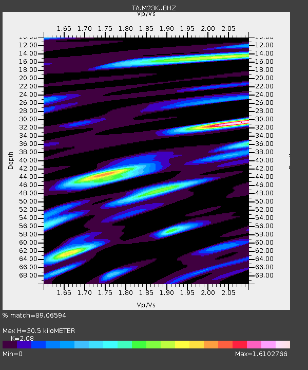
| Estimated Moho Depth: |
30.5 km |
| Estimated Crust Vp/Vs: |
2.08 |
| Assumed Crust Vp: |
6.566 km/s |
| Estimated Crust Vs: |
3.157 km/s |
| Estimated Crust Poisson's Ratio: |
0.35 |
|
| Radial Match: |
89.06594 % |
| Radial Bump: |
400 |
| Transverse Match: |
75.86637 % |
| Transverse Bump: |
400 |
| SOD ConfigId: |
13570011 |
| Insert Time: |
2019-04-28 09:20:54.742 +0000 |
| GWidth: |
2.5 |
| Max Bumps: |
400 |
| Tol: |
0.001 |
|

Signal To Noise
| Channel | StoN | STA | LTA |
| TA:M23K: :BHZ:20170713T03:47:44.47499Z | 21.971191 | 1.1723727E-6 | 5.3359543E-8 |
| TA:M23K: :BHN:20170713T03:47:44.47499Z | 2.2323186 | 3.4518777E-7 | 1.5463193E-7 |
| TA:M23K: :BHE:20170713T03:47:44.47499Z | 4.57726 | 3.3953984E-7 | 7.417972E-8 |
| Arrivals |
| Ps | 5.1 SECOND |
| PpPs | 14 SECOND |
| PsPs/PpSs | 19 SECOND |


