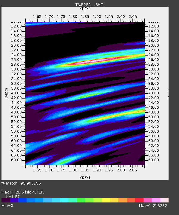
P28A Satin Francis, KS, USA - Earthquake Result Viewer

Earthquake location: Rat Islands, Aleutian Islands
Earthquake latitude/longitude: 50.4/177.0
Earthquake time(UTC): 2009/07/06 (187) 14:53:12 GMT
Earthquake Depth: 22 km
Earthquake Magnitude: 6.0 MB, 5.8 MS, 6.1 MW, 6.0 MW
Earthquake Catalog/Contributor: WHDF/NEIC
Network: TA USArray Transportable Network (new EarthScope stations)
Station: P28A Satin Francis, KS, USA
Lat/Lon: 39.57 N/101.75 W
Elevation: 1105 m
Distance: 55.7 deg
Az: 67.565 deg
Baz: 310.114 deg
Ray Param: 0.06456864
Estimated Moho Depth: 26.5 km
Estimated Crust Vp/Vs: 1.87
Assumed Crust Vp: 6.483 km/s
Estimated Crust Vs: 3.467 km/s
Estimated Crust Poisson's Ratio: 0.30
Radial Match: 95.995155 %
Radial Bump: 344
Transverse Match: 81.415924 %
Transverse Bump: 400
SOD ConfigId: 2622
Insert Time: 2010-03-06 01:49:55.870 +0000
GWidth: 2.5
Max Bumps: 400
Tol: 0.001

Signal To Noise

ChannelStoNSTALTA
TA:P28A: :BHZ:20090706T15:02:16.200022Z22.5578773.179733E-61.4095887E-7
TA:P28A: :BHN:20090706T15:02:16.200022Z8.27061.8281402E-62.210408E-7
TA:P28A: :BHE:20090706T15:02:16.200022Z7.1209571.7951576E-62.52095E-7
Arrivals
Ps3.7 SECOND
PpPs11 SECOND
PsPs/PpSs15 SECOND