You are here: Home > Network List > UW - Pacific Northwest Regional Seismic Network Stations List
> Station LEBA Lebam, WA, USA > Earthquake Result Viewer
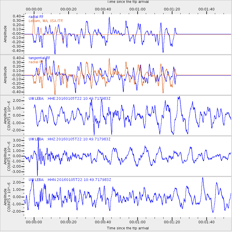
LEBA Lebam, WA, USA - Earthquake Result Viewer
*The percent match for this event was below the threshold and hence no stack was calculated.
| Earthquake location: |
Volcano Islands, Japan Region |
| Earthquake latitude/longitude: |
22.0/143.7 |
| Earthquake time(UTC): |
2016/01/05 (005) 21:59:50 GMT |
| Earthquake Depth: |
158 km |
| Earthquake Magnitude: |
5.9 MB, 5.6 MWB |
| Earthquake Catalog/Contributor: |
NEIC PDE/NEIC COMCAT |
|
| Network: |
UW Pacific Northwest Regional Seismic Network |
| Station: |
LEBA Lebam, WA, USA |
| Lat/Lon: |
46.55 N/123.56 W |
| Elevation: |
73 m |
|
| Distance: |
76.2 deg |
| Az: |
45.236 deg |
| Baz: |
287.377 deg |
| Ray Param: |
$rayparam |
*The percent match for this event was below the threshold and hence was not used in the summary stack. |
|
| Radial Match: |
71.861565 % |
| Radial Bump: |
400 |
| Transverse Match: |
68.0507 % |
| Transverse Bump: |
400 |
| SOD ConfigId: |
1393891 |
| Insert Time: |
2016-01-19 22:48:53.855 +0000 |
| GWidth: |
2.5 |
| Max Bumps: |
400 |
| Tol: |
0.001 |
|
Signal To Noise
| Channel | StoN | STA | LTA |
| UW:LEBA: :HHZ:20160105T22:10:49.717983Z | 2.4836159 | 1.266625E-6 | 5.0999233E-7 |
| UW:LEBA: :HHN:20160105T22:10:49.717983Z | 1.7447875 | 1.1783852E-6 | 6.753746E-7 |
| UW:LEBA: :HHE:20160105T22:10:49.717983Z | 1.3856999 | 1.0298622E-6 | 7.432073E-7 |
| Arrivals |
| Ps | |
| PpPs | |
| PsPs/PpSs | |


