You are here: Home > Network List > TA - USArray Transportable Network (new EarthScope stations) Stations List
> Station P28A Satin Francis, KS, USA > Earthquake Result Viewer
P28A Satin Francis, KS, USA - Earthquake Result Viewer
| Earthquake location: |
Norwegian Sea |
| Earthquake latitude/longitude: |
72.2/0.9 |
| Earthquake time(UTC): |
2009/08/20 (232) 06:35:04 GMT |
| Earthquake Depth: |
6.0 km |
| Earthquake Magnitude: |
5.9 MB, 5.7 MS, 6.0 MW, 6.0 MW |
| Earthquake Catalog/Contributor: |
WHDF/NEIC |
|
| Network: |
TA USArray Transportable Network (new EarthScope stations) |
| Station: |
P28A Satin Francis, KS, USA |
| Lat/Lon: |
39.57 N/101.75 W |
| Elevation: |
1105 m |
|
| Distance: |
56.5 deg |
| Az: |
295.325 deg |
| Baz: |
21.081 deg |
| Ray Param: |
0.06409177 |
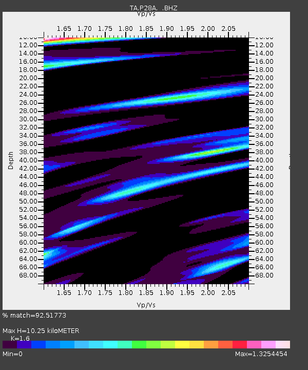
| Estimated Moho Depth: |
10.25 km |
| Estimated Crust Vp/Vs: |
1.60 |
| Assumed Crust Vp: |
6.483 km/s |
| Estimated Crust Vs: |
4.052 km/s |
| Estimated Crust Poisson's Ratio: |
0.18 |
|
| Radial Match: |
92.51773 % |
| Radial Bump: |
286 |
| Transverse Match: |
87.316696 % |
| Transverse Bump: |
400 |
| SOD ConfigId: |
2622 |
| Insert Time: |
2010-03-06 01:50:07.381 +0000 |
| GWidth: |
2.5 |
| Max Bumps: |
400 |
| Tol: |
0.001 |
|

Signal To Noise
| Channel | StoN | STA | LTA |
| TA:P28A: :BHZ:20090820T06:44:16.398994Z | 26.66479 | 1.6928371E-6 | 6.3485864E-8 |
| TA:P28A: :BHN:20090820T06:44:16.398994Z | 6.46069 | 9.781779E-7 | 1.5140456E-7 |
| TA:P28A: :BHE:20090820T06:44:16.398994Z | 5.9482775 | 4.963682E-7 | 8.344738E-8 |
| Arrivals |
| Ps | 1.0 SECOND |
| PpPs | 3.9 SECOND |
| PsPs/PpSs | 4.9 SECOND |


