You are here: Home > Network List > TA - USArray Transportable Network (new EarthScope stations) Stations List
> Station P28A Satin Francis, KS, USA > Earthquake Result Viewer
P28A Satin Francis, KS, USA - Earthquake Result Viewer

| Earthquake location: |
Near Coast Of Venezuela |
| Earthquake latitude/longitude: |
10.7/-67.9 |
| Earthquake time(UTC): |
2009/09/12 (255) 20:06:24 GMT |
| Earthquake Depth: |
10 km |
| Earthquake Magnitude: |
6.3 MB, 6.4 MS, 6.3 MW, 6.3 MW |
| Earthquake Catalog/Contributor: |
WHDF/NEIC |
|
| Network: |
TA USArray Transportable Network (new EarthScope stations) |
| Station: |
P28A Satin Francis, KS, USA |
| Lat/Lon: |
39.57 N/101.75 W |
| Elevation: |
1105 m |
|
| Distance: |
41.6 deg |
| Az: |
319.57 deg |
| Baz: |
124.447 deg |
| Ray Param: |
0.07370575 |
| Estimated Moho Depth: |
43.25 km |
| Estimated Crust Vp/Vs: |
1.92 |
| Assumed Crust Vp: |
6.483 km/s |
| Estimated Crust Vs: |
3.368 km/s |
| Estimated Crust Poisson's Ratio: |
0.32 |
|
| Radial Match: |
89.34145 % |
| Radial Bump: |
219 |
| Transverse Match: |
64.94969 % |
| Transverse Bump: |
324 |
| SOD ConfigId: |
2622 |
| Insert Time: |
2010-03-06 01:50:10.854 +0000 |
| GWidth: |
2.5 |
| Max Bumps: |
400 |
| Tol: |
0.001 |
|
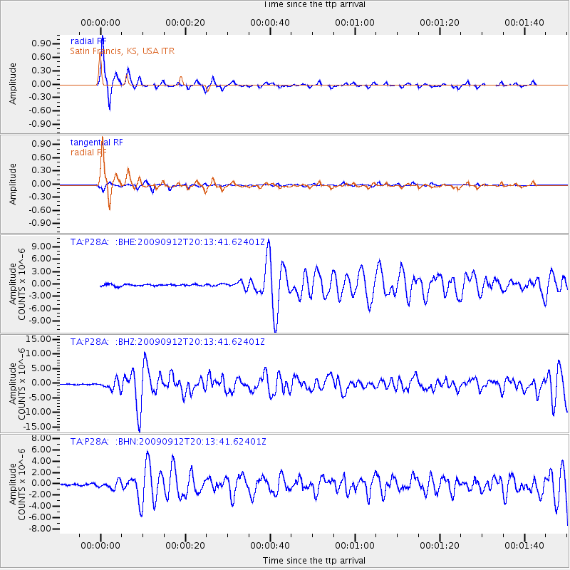
Signal To Noise
| Channel | StoN | STA | LTA |
| TA:P28A: :BHZ:20090912T20:13:41.62401Z | 16.382483 | 1.564812E-6 | 9.551739E-8 |
| TA:P28A: :BHN:20090912T20:13:41.62401Z | 3.4729915 | 6.328771E-7 | 1.8222823E-7 |
| TA:P28A: :BHE:20090912T20:13:41.62401Z | 3.8492703 | 7.748629E-7 | 2.0130125E-7 |
| Arrivals |
| Ps | 6.6 SECOND |
| PpPs | 18 SECOND |
| PsPs/PpSs | 25 SECOND |


