You are here: Home > Network List > TA - USArray Transportable Network (new EarthScope stations) Stations List
> Station P28A Satin Francis, KS, USA > Earthquake Result Viewer
P28A Satin Francis, KS, USA - Earthquake Result Viewer
| Earthquake location: |
Samoa Islands Region |
| Earthquake latitude/longitude: |
-15.5/-172.1 |
| Earthquake time(UTC): |
2009/09/29 (272) 17:48:10 GMT |
| Earthquake Depth: |
18 km |
| Earthquake Magnitude: |
7.1 MB, 8.1 MS, 8.1 MW, 8.0 MW |
| Earthquake Catalog/Contributor: |
WHDF/NEIC |
|
| Network: |
TA USArray Transportable Network (new EarthScope stations) |
| Station: |
P28A Satin Francis, KS, USA |
| Lat/Lon: |
39.57 N/101.75 W |
| Elevation: |
1105 m |
|
| Distance: |
85.3 deg |
| Az: |
46.914 deg |
| Baz: |
245.648 deg |
| Ray Param: |
0.044864856 |
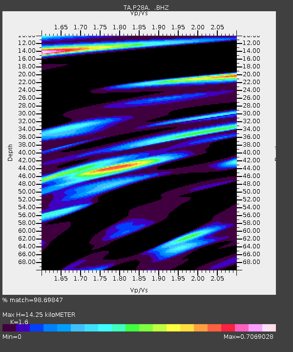
| Estimated Moho Depth: |
14.25 km |
| Estimated Crust Vp/Vs: |
1.60 |
| Assumed Crust Vp: |
6.483 km/s |
| Estimated Crust Vs: |
4.052 km/s |
| Estimated Crust Poisson's Ratio: |
0.18 |
|
| Radial Match: |
98.69847 % |
| Radial Bump: |
340 |
| Transverse Match: |
90.33962 % |
| Transverse Bump: |
400 |
| SOD ConfigId: |
2622 |
| Insert Time: |
2010-03-06 01:50:12.666 +0000 |
| GWidth: |
2.5 |
| Max Bumps: |
400 |
| Tol: |
0.001 |
|
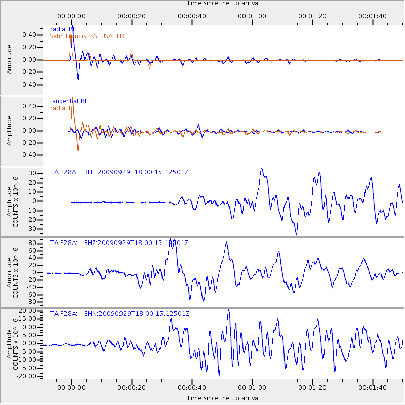
Signal To Noise
| Channel | StoN | STA | LTA |
| TA:P28A: :BHZ:20090929T18:00:15.12501Z | 14.396513 | 3.0327697E-6 | 2.1066002E-7 |
| TA:P28A: :BHN:20090929T18:00:15.12501Z | 1.9277918 | 3.893113E-7 | 2.0194675E-7 |
| TA:P28A: :BHE:20090929T18:00:15.12501Z | 4.6359634 | 1.0265742E-6 | 2.2143709E-7 |
| Arrivals |
| Ps | 1.4 SECOND |
| PpPs | 5.6 SECOND |
| PsPs/PpSs | 6.9 SECOND |


