You are here: Home > Network List > UW - Pacific Northwest Regional Seismic Network Stations List
> Station MRBL Marblemount, WA, USA > Earthquake Result Viewer
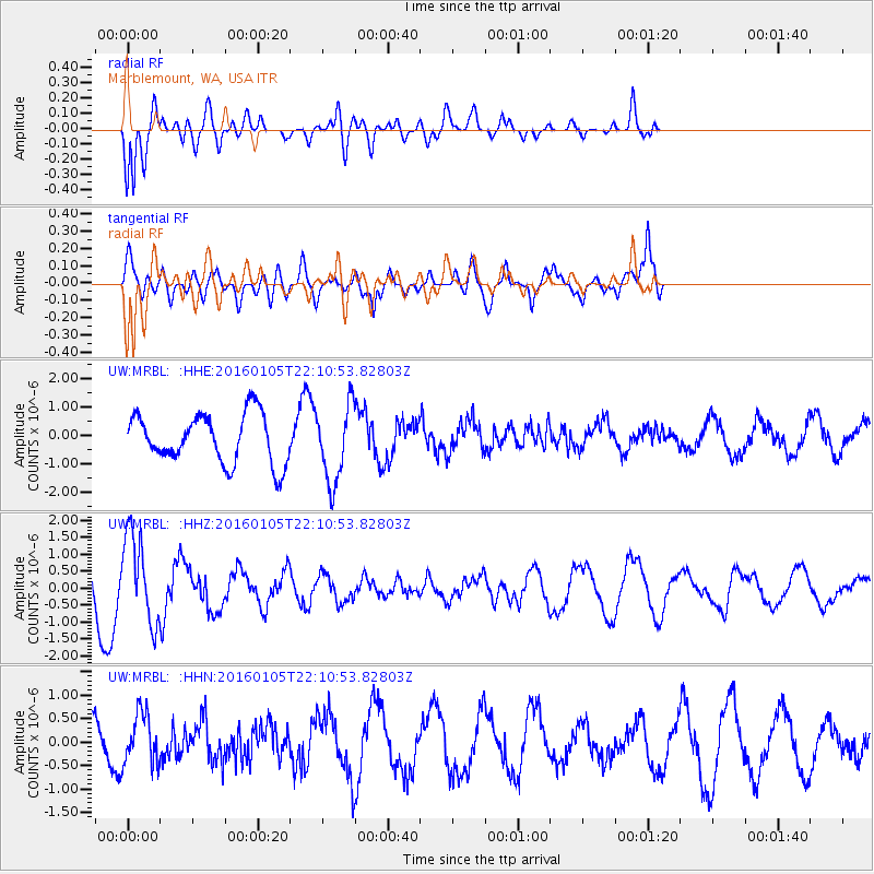
MRBL Marblemount, WA, USA - Earthquake Result Viewer
*The percent match for this event was below the threshold and hence no stack was calculated.
| Earthquake location: |
Volcano Islands, Japan Region |
| Earthquake latitude/longitude: |
22.0/143.7 |
| Earthquake time(UTC): |
2016/01/05 (005) 21:59:50 GMT |
| Earthquake Depth: |
158 km |
| Earthquake Magnitude: |
5.9 MB, 5.6 MWB |
| Earthquake Catalog/Contributor: |
NEIC PDE/NEIC COMCAT |
|
| Network: |
UW Pacific Northwest Regional Seismic Network |
| Station: |
MRBL Marblemount, WA, USA |
| Lat/Lon: |
48.52 N/121.48 W |
| Elevation: |
75 m |
|
| Distance: |
76.9 deg |
| Az: |
42.86 deg |
| Baz: |
288.352 deg |
| Ray Param: |
$rayparam |
*The percent match for this event was below the threshold and hence was not used in the summary stack. |
|
| Radial Match: |
88.73219 % |
| Radial Bump: |
400 |
| Transverse Match: |
67.53626 % |
| Transverse Bump: |
400 |
| SOD ConfigId: |
1393891 |
| Insert Time: |
2016-01-19 22:49:03.876 +0000 |
| GWidth: |
2.5 |
| Max Bumps: |
400 |
| Tol: |
0.001 |
|
Signal To Noise
| Channel | StoN | STA | LTA |
| UW:MRBL: :HHZ:20160105T22:10:53.82803Z | 1.5423009 | 1.2782623E-6 | 8.288021E-7 |
| UW:MRBL: :HHN:20160105T22:10:53.82803Z | 1.5788872 | 5.441116E-7 | 3.4461712E-7 |
| UW:MRBL: :HHE:20160105T22:10:53.82803Z | 1.5764475 | 1.3554832E-6 | 8.5983396E-7 |
| Arrivals |
| Ps | |
| PpPs | |
| PsPs/PpSs | |


