You are here: Home > Network List > UW - Pacific Northwest Regional Seismic Network Stations List
> Station FISH Seaside, OR, USA > Earthquake Result Viewer
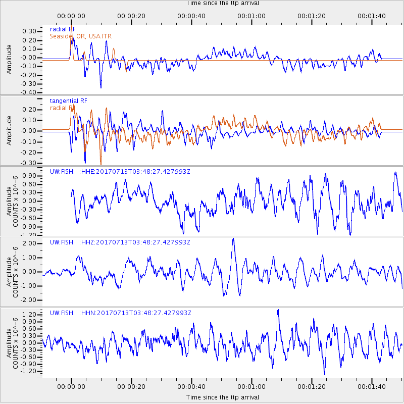
FISH Seaside, OR, USA - Earthquake Result Viewer
*The percent match for this event was below the threshold and hence no stack was calculated.
| Earthquake location: |
New Ireland Region, P.N.G. |
| Earthquake latitude/longitude: |
-4.8/153.2 |
| Earthquake time(UTC): |
2017/07/13 (194) 03:36:09 GMT |
| Earthquake Depth: |
47 km |
| Earthquake Magnitude: |
6.4 mww |
| Earthquake Catalog/Contributor: |
NEIC PDE/us |
|
| Network: |
UW Pacific Northwest Regional Seismic Network |
| Station: |
FISH Seaside, OR, USA |
| Lat/Lon: |
45.93 N/123.56 W |
| Elevation: |
325 m |
|
| Distance: |
88.7 deg |
| Az: |
43.893 deg |
| Baz: |
261.871 deg |
| Ray Param: |
$rayparam |
*The percent match for this event was below the threshold and hence was not used in the summary stack. |
|
| Radial Match: |
63.119884 % |
| Radial Bump: |
400 |
| Transverse Match: |
76.64989 % |
| Transverse Bump: |
400 |
| SOD ConfigId: |
13570011 |
| Insert Time: |
2019-04-28 09:22:26.958 +0000 |
| GWidth: |
2.5 |
| Max Bumps: |
400 |
| Tol: |
0.001 |
|
Signal To Noise
| Channel | StoN | STA | LTA |
| UW:FISH: :HHZ:20170713T03:48:27.427993Z | 4.8149 | 6.3841E-7 | 1.3259049E-7 |
| UW:FISH: :HHN:20170713T03:48:27.427993Z | 1.9353067 | 3.0720946E-7 | 1.5873943E-7 |
| UW:FISH: :HHE:20170713T03:48:27.427993Z | 0.7262349 | 2.3413041E-7 | 3.2238935E-7 |
| Arrivals |
| Ps | |
| PpPs | |
| PsPs/PpSs | |


