You are here: Home > Network List > TA - USArray Transportable Network (new EarthScope stations) Stations List
> Station P28A Satin Francis, KS, USA > Earthquake Result Viewer
P28A Satin Francis, KS, USA - Earthquake Result Viewer
| Earthquake location: |
Baffin Bay |
| Earthquake latitude/longitude: |
75.4/-72.5 |
| Earthquake time(UTC): |
2009/07/07 (188) 19:11:46 GMT |
| Earthquake Depth: |
19 km |
| Earthquake Magnitude: |
5.9 MB, 5.7 MS, 6.1 MW, 6.0 MW |
| Earthquake Catalog/Contributor: |
WHDF/NEIC |
|
| Network: |
TA USArray Transportable Network (new EarthScope stations) |
| Station: |
P28A Satin Francis, KS, USA |
| Lat/Lon: |
39.57 N/101.75 W |
| Elevation: |
1105 m |
|
| Distance: |
38.3 deg |
| Az: |
217.648 deg |
| Baz: |
11.602 deg |
| Ray Param: |
0.075639084 |
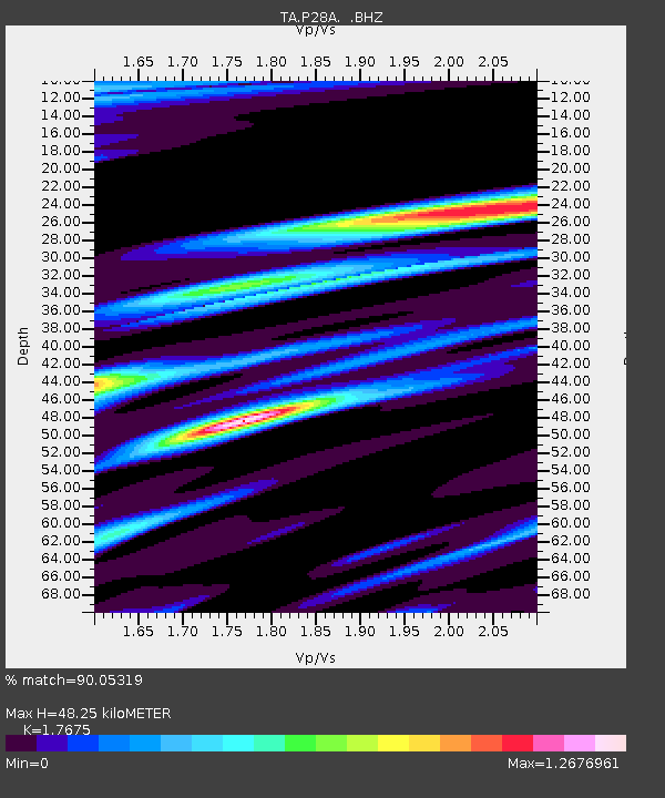
| Estimated Moho Depth: |
48.25 km |
| Estimated Crust Vp/Vs: |
1.77 |
| Assumed Crust Vp: |
6.483 km/s |
| Estimated Crust Vs: |
3.668 km/s |
| Estimated Crust Poisson's Ratio: |
0.26 |
|
| Radial Match: |
90.05319 % |
| Radial Bump: |
316 |
| Transverse Match: |
72.32028 % |
| Transverse Bump: |
400 |
| SOD ConfigId: |
2648 |
| Insert Time: |
2010-03-06 01:50:30.401 +0000 |
| GWidth: |
2.5 |
| Max Bumps: |
400 |
| Tol: |
0.001 |
|

Signal To Noise
| Channel | StoN | STA | LTA |
| TA:P28A: :BHZ:20090707T19:18:34.900002Z | 11.423518 | 1.2324115E-6 | 1.0788371E-7 |
| TA:P28A: :BHN:20090707T19:18:34.900002Z | 7.1357546 | 1.1997846E-6 | 1.6813703E-7 |
| TA:P28A: :BHE:20090707T19:18:34.900002Z | 1.6393404 | 2.3447278E-7 | 1.4302873E-7 |
| Arrivals |
| Ps | 6.2 SECOND |
| PpPs | 19 SECOND |
| PsPs/PpSs | 25 SECOND |


