You are here: Home > Network List > GO - National Seismic Network of Georgia Stations List
> Station AKH Akhalkalaki > Earthquake Result Viewer
AKH Akhalkalaki - Earthquake Result Viewer
| Earthquake location: |
Minahassa Peninsula, Sulawesi |
| Earthquake latitude/longitude: |
0.4/122.0 |
| Earthquake time(UTC): |
2017/07/15 (196) 12:12:21 GMT |
| Earthquake Depth: |
114 km |
| Earthquake Magnitude: |
5.9 Mww |
| Earthquake Catalog/Contributor: |
NEIC PDE/us |
|
| Network: |
GO National Seismic Network of Georgia |
| Station: |
AKH Akhalkalaki |
| Lat/Lon: |
41.41 N/43.49 E |
| Elevation: |
1720 m |
|
| Distance: |
81.1 deg |
| Az: |
311.747 deg |
| Baz: |
97.311 deg |
| Ray Param: |
0.047534972 |
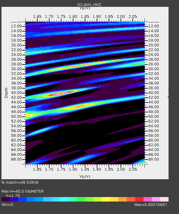
| Estimated Moho Depth: |
40.0 km |
| Estimated Crust Vp/Vs: |
1.75 |
| Assumed Crust Vp: |
6.419 km/s |
| Estimated Crust Vs: |
3.668 km/s |
| Estimated Crust Poisson's Ratio: |
0.26 |
|
| Radial Match: |
89.53938 % |
| Radial Bump: |
400 |
| Transverse Match: |
67.71271 % |
| Transverse Bump: |
400 |
| SOD ConfigId: |
13570011 |
| Insert Time: |
2019-04-28 09:25:40.462 +0000 |
| GWidth: |
2.5 |
| Max Bumps: |
400 |
| Tol: |
0.001 |
|

Signal To Noise
| Channel | StoN | STA | LTA |
| GO:AKH: :HHZ:20170715T12:23:53.17002Z | 12.802025 | 2.4411302E-6 | 1.9068312E-7 |
| GO:AKH: :HHN:20170715T12:23:53.17002Z | 0.65859926 | 3.109309E-7 | 4.7210938E-7 |
| GO:AKH: :HHE:20170715T12:23:53.17002Z | 3.1142092 | 6.342644E-7 | 2.0366788E-7 |
| Arrivals |
| Ps | 4.8 SECOND |
| PpPs | 17 SECOND |
| PsPs/PpSs | 21 SECOND |


