You are here: Home > Network List > JP - Japan Meteorological Agency Seismic Network Stations List
> Station JCJ Chichijima Island > Earthquake Result Viewer
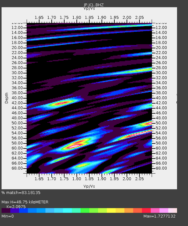
JCJ Chichijima Island - Earthquake Result Viewer
| Earthquake location: |
Minahassa Peninsula, Sulawesi |
| Earthquake latitude/longitude: |
0.4/122.0 |
| Earthquake time(UTC): |
2017/07/15 (196) 12:12:21 GMT |
| Earthquake Depth: |
114 km |
| Earthquake Magnitude: |
5.9 Mww |
| Earthquake Catalog/Contributor: |
NEIC PDE/us |
|
| Network: |
JP Japan Meteorological Agency Seismic Network |
| Station: |
JCJ Chichijima Island |
| Lat/Lon: |
27.10 N/142.18 E |
| Elevation: |
150 m |
|
| Distance: |
32.9 deg |
| Az: |
34.482 deg |
| Baz: |
219.423 deg |
| Ray Param: |
0.07814166 |
| Estimated Moho Depth: |
49.75 km |
| Estimated Crust Vp/Vs: |
2.10 |
| Assumed Crust Vp: |
4.24 km/s |
| Estimated Crust Vs: |
2.021 km/s |
| Estimated Crust Poisson's Ratio: |
0.35 |
|
| Radial Match: |
83.18135 % |
| Radial Bump: |
400 |
| Transverse Match: |
79.46012 % |
| Transverse Bump: |
400 |
| SOD ConfigId: |
13570011 |
| Insert Time: |
2019-04-28 09:26:01.249 +0000 |
| GWidth: |
2.5 |
| Max Bumps: |
400 |
| Tol: |
0.001 |
|

Signal To Noise
| Channel | StoN | STA | LTA |
| JP:JCJ: :BHZ:20170715T12:18:14.400Z | 14.612264 | 4.1062476E-6 | 2.810138E-7 |
| JP:JCJ: :BHN:20170715T12:18:14.400Z | 7.4682784 | 2.262382E-6 | 3.029322E-7 |
| JP:JCJ: :BHE:20170715T12:18:14.400Z | 8.335195 | 3.1740344E-6 | 3.8079907E-7 |
| Arrivals |
| Ps | 13 SECOND |
| PpPs | 35 SECOND |
| PsPs/PpSs | 49 SECOND |


