You are here: Home > Network List > TA - USArray Transportable Network (new EarthScope stations) Stations List
> Station M29A Burnside Ranch, Stapleton, NE, USA > Earthquake Result Viewer
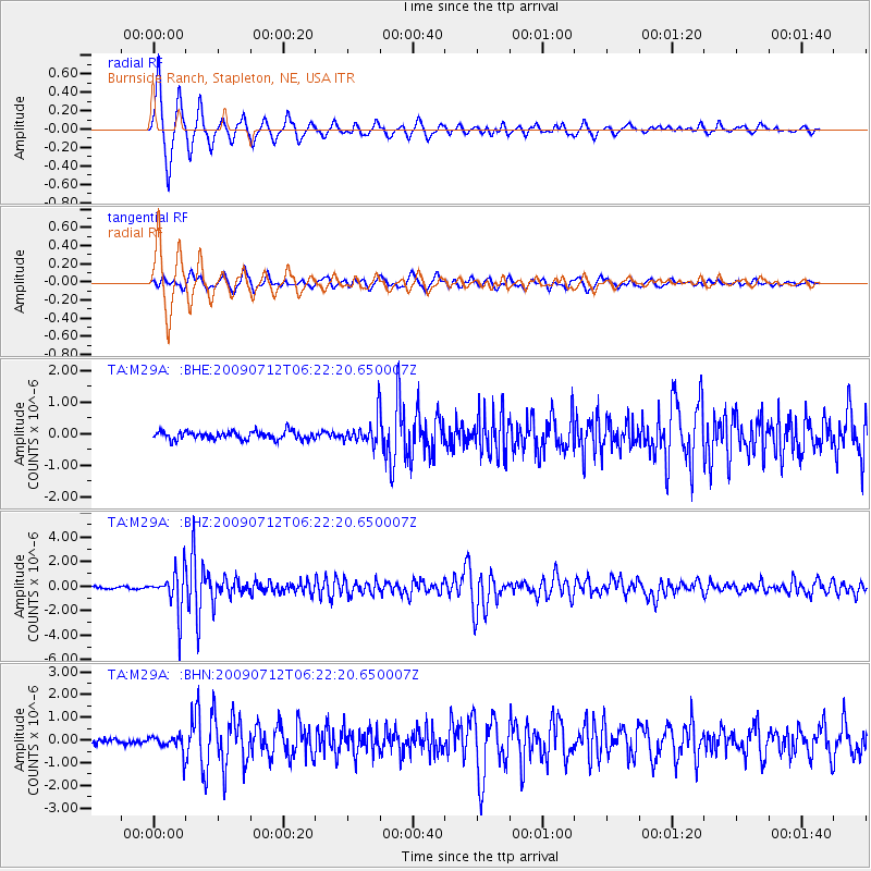
M29A Burnside Ranch, Stapleton, NE, USA - Earthquake Result Viewer

| Earthquake location: |
Southern Peru |
| Earthquake latitude/longitude: |
-15.0/-70.4 |
| Earthquake time(UTC): |
2009/07/12 (193) 06:12:47 GMT |
| Earthquake Depth: |
199 km |
| Earthquake Magnitude: |
5.7 MB, 6.1 MW, 6.1 MW |
| Earthquake Catalog/Contributor: |
WHDF/NEIC |
|
| Network: |
TA USArray Transportable Network (new EarthScope stations) |
| Station: |
M29A Burnside Ranch, Stapleton, NE, USA |
| Lat/Lon: |
41.44 N/100.69 W |
| Elevation: |
952 m |
|
| Distance: |
62.8 deg |
| Az: |
334.796 deg |
| Baz: |
146.82 deg |
| Ray Param: |
0.059399374 |
| Estimated Moho Depth: |
12.0 km |
| Estimated Crust Vp/Vs: |
1.60 |
| Assumed Crust Vp: |
6.483 km/s |
| Estimated Crust Vs: |
4.052 km/s |
| Estimated Crust Poisson's Ratio: |
0.18 |
|
| Radial Match: |
94.367035 % |
| Radial Bump: |
290 |
| Transverse Match: |
85.21601 % |
| Transverse Bump: |
358 |
| SOD ConfigId: |
2648 |
| Insert Time: |
2010-03-06 01:51:19.906 +0000 |
| GWidth: |
2.5 |
| Max Bumps: |
400 |
| Tol: |
0.001 |
|
Signal To Noise
| Channel | StoN | STA | LTA |
| TA:M29A: :BHZ:20090712T06:22:20.650007Z | 20.796743 | 1.6371924E-6 | 7.8723495E-8 |
| TA:M29A: :BHN:20090712T06:22:20.650007Z | 2.6640048 | 3.8932563E-7 | 1.46143E-7 |
| TA:M29A: :BHE:20090712T06:22:20.650007Z | 3.191325 | 4.1039183E-7 | 1.2859607E-7 |
| Arrivals |
| Ps | 1.2 SECOND |
| PpPs | 4.6 SECOND |
| PsPs/PpSs | 5.7 SECOND |


