You are here: Home > Network List > MM - Myanmar National Seismic Network Stations List
> Station MDY Mandalay, Mandalay, Myanmar > Earthquake Result Viewer
MDY Mandalay, Mandalay, Myanmar - Earthquake Result Viewer
| Earthquake location: |
Minahassa Peninsula, Sulawesi |
| Earthquake latitude/longitude: |
0.4/122.0 |
| Earthquake time(UTC): |
2017/07/15 (196) 12:12:21 GMT |
| Earthquake Depth: |
114 km |
| Earthquake Magnitude: |
5.9 Mww |
| Earthquake Catalog/Contributor: |
NEIC PDE/us |
|
| Network: |
MM Myanmar National Seismic Network |
| Station: |
MDY Mandalay, Mandalay, Myanmar |
| Lat/Lon: |
22.02 N/96.11 E |
| Elevation: |
97 m |
|
| Distance: |
33.2 deg |
| Az: |
312.134 deg |
| Baz: |
126.952 deg |
| Ray Param: |
0.07800562 |
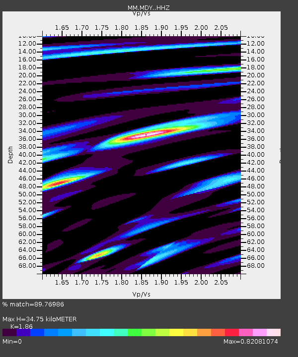
| Estimated Moho Depth: |
34.75 km |
| Estimated Crust Vp/Vs: |
1.86 |
| Assumed Crust Vp: |
6.316 km/s |
| Estimated Crust Vs: |
3.395 km/s |
| Estimated Crust Poisson's Ratio: |
0.30 |
|
| Radial Match: |
89.76986 % |
| Radial Bump: |
399 |
| Transverse Match: |
82.23927 % |
| Transverse Bump: |
400 |
| SOD ConfigId: |
13570011 |
| Insert Time: |
2019-04-28 09:26:32.104 +0000 |
| GWidth: |
2.5 |
| Max Bumps: |
400 |
| Tol: |
0.001 |
|

Signal To Noise
| Channel | StoN | STA | LTA |
| MM:MDY: :HHZ:20170715T12:18:16.538Z | 22.653887 | 1.1214473E-6 | 4.950353E-8 |
| MM:MDY: :HHN:20170715T12:18:16.538Z | 7.6590643 | 4.0164457E-7 | 5.2440424E-8 |
| MM:MDY: :HHE:20170715T12:18:16.538Z | 5.7276917 | 3.7471705E-7 | 6.5422E-8 |
| Arrivals |
| Ps | 5.1 SECOND |
| PpPs | 15 SECOND |
| PsPs/PpSs | 20 SECOND |


