You are here: Home > Network List > TA - USArray Transportable Network (new EarthScope stations) Stations List
> Station E22K Anaktuvuk Pass, AK, USA > Earthquake Result Viewer
E22K Anaktuvuk Pass, AK, USA - Earthquake Result Viewer
| Earthquake location: |
Minahassa Peninsula, Sulawesi |
| Earthquake latitude/longitude: |
0.4/122.0 |
| Earthquake time(UTC): |
2017/07/15 (196) 12:12:21 GMT |
| Earthquake Depth: |
114 km |
| Earthquake Magnitude: |
5.9 Mww |
| Earthquake Catalog/Contributor: |
NEIC PDE/us |
|
| Network: |
TA USArray Transportable Network (new EarthScope stations) |
| Station: |
E22K Anaktuvuk Pass, AK, USA |
| Lat/Lon: |
68.13 N/151.81 W |
| Elevation: |
772 m |
|
| Distance: |
88.2 deg |
| Az: |
21.958 deg |
| Baz: |
266.585 deg |
| Ray Param: |
0.042524274 |
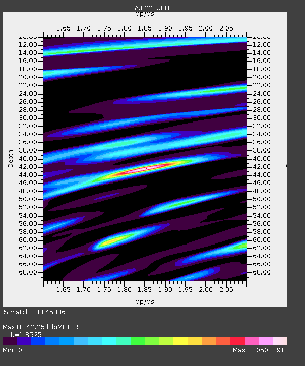
| Estimated Moho Depth: |
42.25 km |
| Estimated Crust Vp/Vs: |
1.85 |
| Assumed Crust Vp: |
6.221 km/s |
| Estimated Crust Vs: |
3.358 km/s |
| Estimated Crust Poisson's Ratio: |
0.29 |
|
| Radial Match: |
88.45886 % |
| Radial Bump: |
400 |
| Transverse Match: |
81.393745 % |
| Transverse Bump: |
400 |
| SOD ConfigId: |
13570011 |
| Insert Time: |
2019-04-28 09:27:10.235 +0000 |
| GWidth: |
2.5 |
| Max Bumps: |
400 |
| Tol: |
0.001 |
|

Signal To Noise
| Channel | StoN | STA | LTA |
| TA:E22K: :BHZ:20170715T12:24:28.650Z | 14.271125 | 4.2818687E-7 | 3.0003722E-8 |
| TA:E22K: :BHN:20170715T12:24:28.650Z | 2.023488 | 5.5835915E-8 | 2.7593893E-8 |
| TA:E22K: :BHE:20170715T12:24:28.650Z | 4.8467097 | 1.15166586E-7 | 2.3761809E-8 |
| Arrivals |
| Ps | 5.9 SECOND |
| PpPs | 19 SECOND |
| PsPs/PpSs | 25 SECOND |


