You are here: Home > Network List > TA - USArray Transportable Network (new EarthScope stations) Stations List
> Station J14K Nanvaranak Lake, AK, USA > Earthquake Result Viewer
J14K Nanvaranak Lake, AK, USA - Earthquake Result Viewer
| Earthquake location: |
Minahassa Peninsula, Sulawesi |
| Earthquake latitude/longitude: |
0.4/122.0 |
| Earthquake time(UTC): |
2017/07/15 (196) 12:12:21 GMT |
| Earthquake Depth: |
114 km |
| Earthquake Magnitude: |
5.9 Mww |
| Earthquake Catalog/Contributor: |
NEIC PDE/us |
|
| Network: |
TA USArray Transportable Network (new EarthScope stations) |
| Station: |
J14K Nanvaranak Lake, AK, USA |
| Lat/Lon: |
62.75 N/163.55 W |
| Elevation: |
25 m |
|
| Distance: |
82.5 deg |
| Az: |
26.563 deg |
| Baz: |
256.273 deg |
| Ray Param: |
0.046562262 |
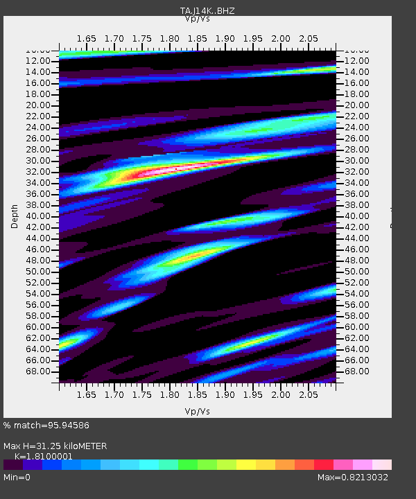
| Estimated Moho Depth: |
31.25 km |
| Estimated Crust Vp/Vs: |
1.81 |
| Assumed Crust Vp: |
6.155 km/s |
| Estimated Crust Vs: |
3.4 km/s |
| Estimated Crust Poisson's Ratio: |
0.28 |
|
| Radial Match: |
95.94586 % |
| Radial Bump: |
385 |
| Transverse Match: |
90.90029 % |
| Transverse Bump: |
400 |
| SOD ConfigId: |
13570011 |
| Insert Time: |
2019-04-28 09:27:41.986 +0000 |
| GWidth: |
2.5 |
| Max Bumps: |
400 |
| Tol: |
0.001 |
|

Signal To Noise
| Channel | StoN | STA | LTA |
| TA:J14K: :BHZ:20170715T12:24:00.725012Z | 20.94549 | 8.416647E-7 | 4.0183576E-8 |
| TA:J14K: :BHN:20170715T12:24:00.725012Z | 4.5880866 | 1.366235E-7 | 2.9777881E-8 |
| TA:J14K: :BHE:20170715T12:24:00.725012Z | 9.293854 | 3.259073E-7 | 3.506697E-8 |
| Arrivals |
| Ps | 4.2 SECOND |
| PpPs | 14 SECOND |
| PsPs/PpSs | 18 SECOND |


