You are here: Home > Network List > TA - USArray Transportable Network (new EarthScope stations) Stations List
> Station K15K Wolf Creek Mountain, AK, USA > Earthquake Result Viewer
K15K Wolf Creek Mountain, AK, USA - Earthquake Result Viewer
| Earthquake location: |
Minahassa Peninsula, Sulawesi |
| Earthquake latitude/longitude: |
0.4/122.0 |
| Earthquake time(UTC): |
2017/07/15 (196) 12:12:21 GMT |
| Earthquake Depth: |
114 km |
| Earthquake Magnitude: |
5.9 Mww |
| Earthquake Catalog/Contributor: |
NEIC PDE/us |
|
| Network: |
TA USArray Transportable Network (new EarthScope stations) |
| Station: |
K15K Wolf Creek Mountain, AK, USA |
| Lat/Lon: |
62.29 N/161.53 W |
| Elevation: |
346 m |
|
| Distance: |
83.4 deg |
| Az: |
27.222 deg |
| Baz: |
258.146 deg |
| Ray Param: |
0.045991194 |
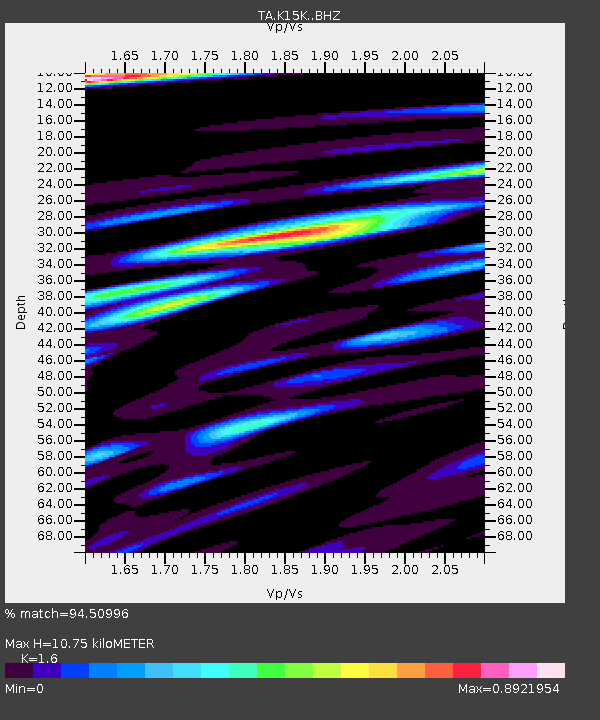
| Estimated Moho Depth: |
10.75 km |
| Estimated Crust Vp/Vs: |
1.60 |
| Assumed Crust Vp: |
6.276 km/s |
| Estimated Crust Vs: |
3.922 km/s |
| Estimated Crust Poisson's Ratio: |
0.18 |
|
| Radial Match: |
94.50996 % |
| Radial Bump: |
400 |
| Transverse Match: |
93.33904 % |
| Transverse Bump: |
400 |
| SOD ConfigId: |
13570011 |
| Insert Time: |
2019-04-28 09:27:51.720 +0000 |
| GWidth: |
2.5 |
| Max Bumps: |
400 |
| Tol: |
0.001 |
|

Signal To Noise
| Channel | StoN | STA | LTA |
| TA:K15K: :BHZ:20170715T12:24:04.900Z | 31.211262 | 1.1081482E-6 | 3.5504755E-8 |
| TA:K15K: :BHN:20170715T12:24:04.900Z | 3.851142 | 1.6465972E-7 | 4.2756078E-8 |
| TA:K15K: :BHE:20170715T12:24:04.900Z | 8.980946 | 4.4408478E-7 | 4.9447436E-8 |
| Arrivals |
| Ps | 1.1 SECOND |
| PpPs | 4.3 SECOND |
| PsPs/PpSs | 5.4 SECOND |


