You are here: Home > Network List > TA - USArray Transportable Network (new EarthScope stations) Stations List
> Station M11K Mekoryuk, AK, USA > Earthquake Result Viewer
M11K Mekoryuk, AK, USA - Earthquake Result Viewer
| Earthquake location: |
Minahassa Peninsula, Sulawesi |
| Earthquake latitude/longitude: |
0.4/122.0 |
| Earthquake time(UTC): |
2017/07/15 (196) 12:12:21 GMT |
| Earthquake Depth: |
114 km |
| Earthquake Magnitude: |
5.9 Mww |
| Earthquake Catalog/Contributor: |
NEIC PDE/us |
|
| Network: |
TA USArray Transportable Network (new EarthScope stations) |
| Station: |
M11K Mekoryuk, AK, USA |
| Lat/Lon: |
60.38 N/166.20 W |
| Elevation: |
3.0 m |
|
| Distance: |
80.7 deg |
| Az: |
28.556 deg |
| Baz: |
254.238 deg |
| Ray Param: |
0.04783245 |
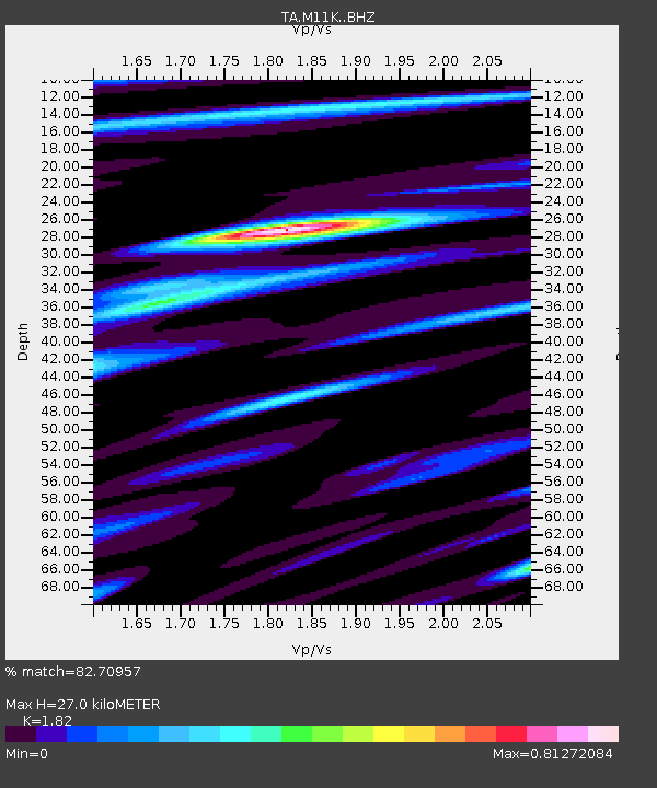
| Estimated Moho Depth: |
27.0 km |
| Estimated Crust Vp/Vs: |
1.82 |
| Assumed Crust Vp: |
6.134 km/s |
| Estimated Crust Vs: |
3.37 km/s |
| Estimated Crust Poisson's Ratio: |
0.28 |
|
| Radial Match: |
82.70957 % |
| Radial Bump: |
400 |
| Transverse Match: |
80.09592 % |
| Transverse Bump: |
400 |
| SOD ConfigId: |
13570011 |
| Insert Time: |
2019-04-28 09:28:01.032 +0000 |
| GWidth: |
2.5 |
| Max Bumps: |
400 |
| Tol: |
0.001 |
|
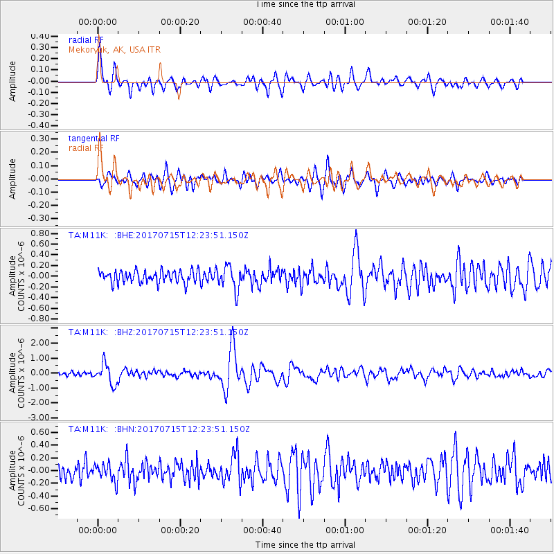
Signal To Noise
| Channel | StoN | STA | LTA |
| TA:M11K: :BHZ:20170715T12:23:51.150Z | 6.797975 | 6.9737615E-7 | 1.0258587E-7 |
| TA:M11K: :BHN:20170715T12:23:51.150Z | 1.3360119 | 1.382665E-7 | 1.0349197E-7 |
| TA:M11K: :BHE:20170715T12:23:51.150Z | 2.0260186 | 2.2841836E-7 | 1.1274247E-7 |
| Arrivals |
| Ps | 3.7 SECOND |
| PpPs | 12 SECOND |
| PsPs/PpSs | 16 SECOND |


