You are here: Home > Network List > TA - USArray Transportable Network (new EarthScope stations) Stations List
> Station Q30A Quinter, KS, USA > Earthquake Result Viewer
Q30A Quinter, KS, USA - Earthquake Result Viewer
| Earthquake location: |
Southeast Of Honshu, Japan |
| Earthquake latitude/longitude: |
32.8/140.4 |
| Earthquake time(UTC): |
2009/08/12 (224) 22:48:51 GMT |
| Earthquake Depth: |
53 km |
| Earthquake Magnitude: |
6.2 MB, 6.6 MW, 6.6 MW |
| Earthquake Catalog/Contributor: |
WHDF/NEIC |
|
| Network: |
TA USArray Transportable Network (new EarthScope stations) |
| Station: |
Q30A Quinter, KS, USA |
| Lat/Lon: |
38.98 N/100.22 W |
| Elevation: |
797 m |
|
| Distance: |
89.1 deg |
| Az: |
42.786 deg |
| Baz: |
312.795 deg |
| Ray Param: |
0.04201712 |
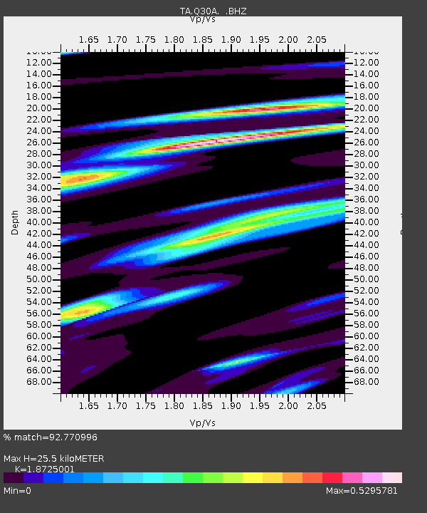
| Estimated Moho Depth: |
25.5 km |
| Estimated Crust Vp/Vs: |
1.87 |
| Assumed Crust Vp: |
6.483 km/s |
| Estimated Crust Vs: |
3.462 km/s |
| Estimated Crust Poisson's Ratio: |
0.30 |
|
| Radial Match: |
92.770996 % |
| Radial Bump: |
378 |
| Transverse Match: |
82.72731 % |
| Transverse Bump: |
400 |
| SOD ConfigId: |
2622 |
| Insert Time: |
2010-03-06 01:51:54.829 +0000 |
| GWidth: |
2.5 |
| Max Bumps: |
400 |
| Tol: |
0.001 |
|
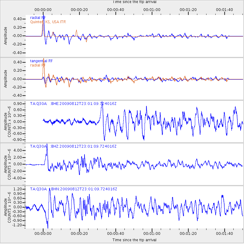
Signal To Noise
| Channel | StoN | STA | LTA |
| TA:Q30A: :BHZ:20090812T23:01:09.724016Z | 33.07867 | 1.9249012E-6 | 5.8191613E-8 |
| TA:Q30A: :BHN:20090812T23:01:09.724016Z | 7.868784 | 6.640465E-7 | 8.438998E-8 |
| TA:Q30A: :BHE:20090812T23:01:09.724016Z | 7.0625978 | 4.932315E-7 | 6.983712E-8 |
| Arrivals |
| Ps | 3.5 SECOND |
| PpPs | 11 SECOND |
| PsPs/PpSs | 15 SECOND |


