You are here: Home > Network List > TA - USArray Transportable Network (new EarthScope stations) Stations List
> Station N25K Chitina, Valdez-Cordova, AK, USA > Earthquake Result Viewer
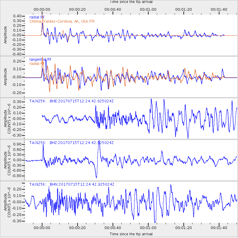
N25K Chitina, Valdez-Cordova, AK, USA - Earthquake Result Viewer
*The percent match for this event was below the threshold and hence no stack was calculated.
| Earthquake location: |
Minahassa Peninsula, Sulawesi |
| Earthquake latitude/longitude: |
0.4/122.0 |
| Earthquake time(UTC): |
2017/07/15 (196) 12:12:21 GMT |
| Earthquake Depth: |
114 km |
| Earthquake Magnitude: |
5.9 Mww |
| Earthquake Catalog/Contributor: |
NEIC PDE/us |
|
| Network: |
TA USArray Transportable Network (new EarthScope stations) |
| Station: |
N25K Chitina, Valdez-Cordova, AK, USA |
| Lat/Lon: |
61.61 N/144.60 W |
| Elevation: |
1087 m |
|
| Distance: |
91.3 deg |
| Az: |
28.509 deg |
| Baz: |
273.153 deg |
| Ray Param: |
$rayparam |
*The percent match for this event was below the threshold and hence was not used in the summary stack. |
|
| Radial Match: |
79.17062 % |
| Radial Bump: |
400 |
| Transverse Match: |
79.24554 % |
| Transverse Bump: |
400 |
| SOD ConfigId: |
13570011 |
| Insert Time: |
2019-04-28 09:28:20.362 +0000 |
| GWidth: |
2.5 |
| Max Bumps: |
400 |
| Tol: |
0.001 |
|
Signal To Noise
| Channel | StoN | STA | LTA |
| TA:N25K: :BHZ:20170715T12:24:42.925024Z | 7.7785378 | 2.7710078E-7 | 3.562376E-8 |
| TA:N25K: :BHN:20170715T12:24:42.925024Z | 2.2547877 | 9.3428795E-8 | 4.1435744E-8 |
| TA:N25K: :BHE:20170715T12:24:42.925024Z | 2.2410765 | 9.070836E-8 | 4.0475353E-8 |
| Arrivals |
| Ps | |
| PpPs | |
| PsPs/PpSs | |


