You are here: Home > Network List > TA - USArray Transportable Network (new EarthScope stations) Stations List
> Station P17K Kvichak River, AK, USA > Earthquake Result Viewer
P17K Kvichak River, AK, USA - Earthquake Result Viewer
| Earthquake location: |
Minahassa Peninsula, Sulawesi |
| Earthquake latitude/longitude: |
0.4/122.0 |
| Earthquake time(UTC): |
2017/07/15 (196) 12:12:21 GMT |
| Earthquake Depth: |
114 km |
| Earthquake Magnitude: |
5.9 Mww |
| Earthquake Catalog/Contributor: |
NEIC PDE/us |
|
| Network: |
TA USArray Transportable Network (new EarthScope stations) |
| Station: |
P17K Kvichak River, AK, USA |
| Lat/Lon: |
59.20 N/156.44 W |
| Elevation: |
91 m |
|
| Distance: |
85.3 deg |
| Az: |
30.714 deg |
| Baz: |
262.928 deg |
| Ray Param: |
0.04460606 |
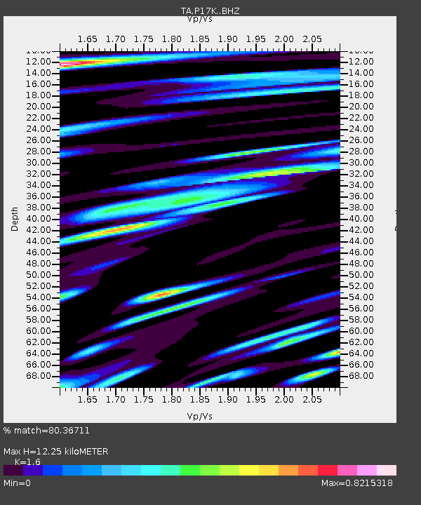
| Estimated Moho Depth: |
12.25 km |
| Estimated Crust Vp/Vs: |
1.60 |
| Assumed Crust Vp: |
6.276 km/s |
| Estimated Crust Vs: |
3.922 km/s |
| Estimated Crust Poisson's Ratio: |
0.18 |
|
| Radial Match: |
80.36711 % |
| Radial Bump: |
400 |
| Transverse Match: |
80.25283 % |
| Transverse Bump: |
400 |
| SOD ConfigId: |
13570011 |
| Insert Time: |
2019-04-28 09:28:31.674 +0000 |
| GWidth: |
2.5 |
| Max Bumps: |
400 |
| Tol: |
0.001 |
|
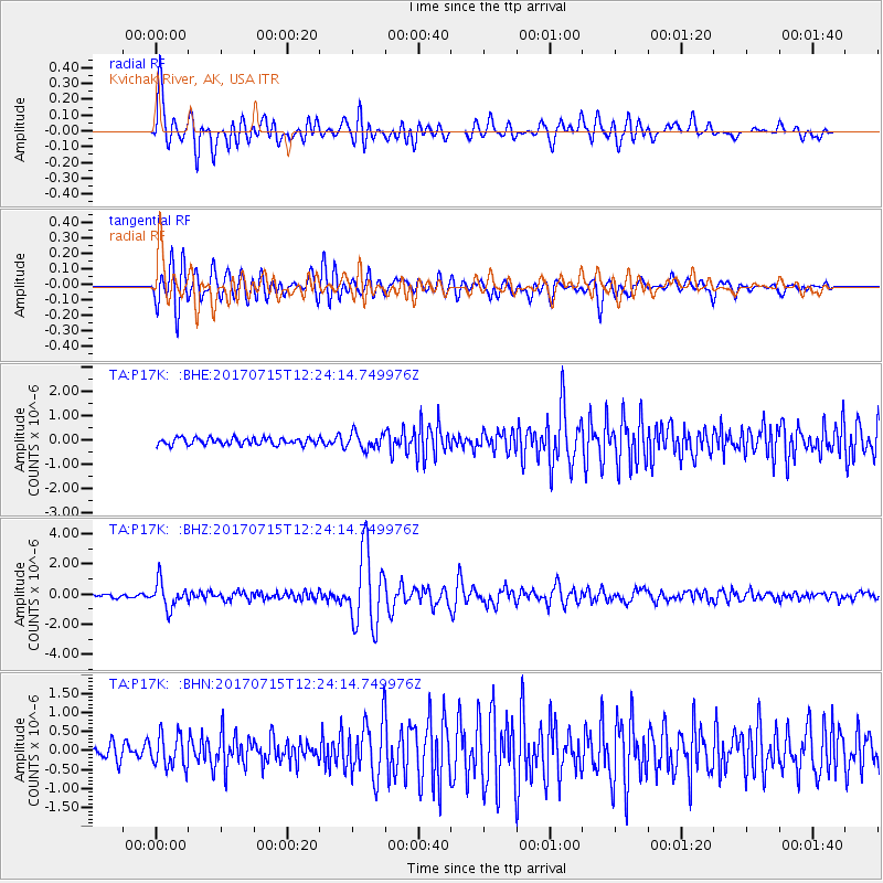
Signal To Noise
| Channel | StoN | STA | LTA |
| TA:P17K: :BHZ:20170715T12:24:14.749976Z | 8.327215 | 8.6009754E-7 | 1.0328753E-7 |
| TA:P17K: :BHN:20170715T12:24:14.749976Z | 1.8441862 | 4.2743687E-7 | 2.3177533E-7 |
| TA:P17K: :BHE:20170715T12:24:14.749976Z | 2.366935 | 3.334346E-7 | 1.4087188E-7 |
| Arrivals |
| Ps | 1.2 SECOND |
| PpPs | 4.9 SECOND |
| PsPs/PpSs | 6.1 SECOND |


