You are here: Home > Network List > TA - USArray Transportable Network (new EarthScope stations) Stations List
> Station Q30A Quinter, KS, USA > Earthquake Result Viewer
Q30A Quinter, KS, USA - Earthquake Result Viewer
| Earthquake location: |
Tonga Islands |
| Earthquake latitude/longitude: |
-15.4/-173.3 |
| Earthquake time(UTC): |
2009/10/01 (274) 06:13:32 GMT |
| Earthquake Depth: |
10 km |
| Earthquake Magnitude: |
5.6 MB, 5.7 MS, 5.8 MW, 5.7 MW |
| Earthquake Catalog/Contributor: |
WHDF/NEIC |
|
| Network: |
TA USArray Transportable Network (new EarthScope stations) |
| Station: |
Q30A Quinter, KS, USA |
| Lat/Lon: |
38.98 N/100.22 W |
| Elevation: |
797 m |
|
| Distance: |
86.9 deg |
| Az: |
48.298 deg |
| Baz: |
247.514 deg |
| Ray Param: |
0.043722622 |
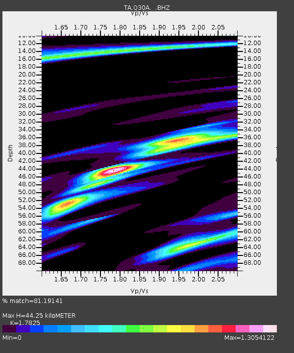
| Estimated Moho Depth: |
44.25 km |
| Estimated Crust Vp/Vs: |
1.78 |
| Assumed Crust Vp: |
6.483 km/s |
| Estimated Crust Vs: |
3.637 km/s |
| Estimated Crust Poisson's Ratio: |
0.27 |
|
| Radial Match: |
81.19141 % |
| Radial Bump: |
394 |
| Transverse Match: |
59.180454 % |
| Transverse Bump: |
376 |
| SOD ConfigId: |
2622 |
| Insert Time: |
2010-03-06 01:52:04.984 +0000 |
| GWidth: |
2.5 |
| Max Bumps: |
400 |
| Tol: |
0.001 |
|

Signal To Noise
| Channel | StoN | STA | LTA |
| TA:Q30A: :BHZ:20091001T06:25:45.949011Z | 5.5046854 | 3.7341582E-7 | 6.7836E-8 |
| TA:Q30A: :BHN:20091001T06:25:45.949011Z | 1.0599458 | 1.6317038E-7 | 1.5394218E-7 |
| TA:Q30A: :BHE:20091001T06:25:45.949011Z | 1.3295058 | 2.2656214E-7 | 1.704108E-7 |
| Arrivals |
| Ps | 5.5 SECOND |
| PpPs | 19 SECOND |
| PsPs/PpSs | 24 SECOND |


