You are here: Home > Network List > TA - USArray Transportable Network (new EarthScope stations) Stations List
> Station R17K Ugashik Creek, AK, USA > Earthquake Result Viewer
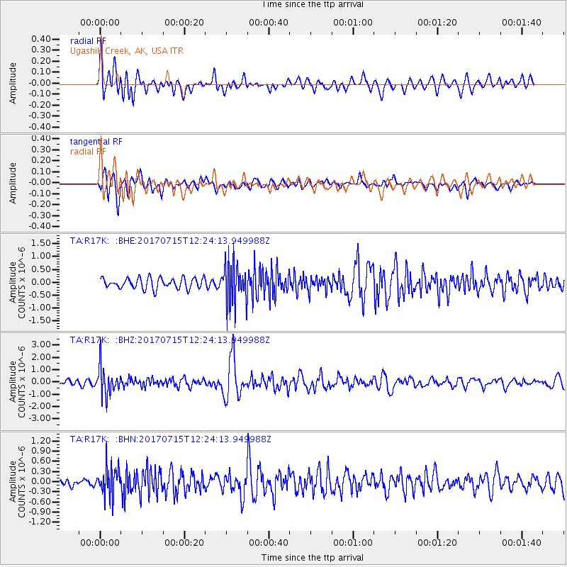
R17K Ugashik Creek, AK, USA - Earthquake Result Viewer
*The percent match for this event was below the threshold and hence no stack was calculated.
| Earthquake location: |
Minahassa Peninsula, Sulawesi |
| Earthquake latitude/longitude: |
0.4/122.0 |
| Earthquake time(UTC): |
2017/07/15 (196) 12:12:21 GMT |
| Earthquake Depth: |
114 km |
| Earthquake Magnitude: |
5.9 Mww |
| Earthquake Catalog/Contributor: |
NEIC PDE/us |
|
| Network: |
TA USArray Transportable Network (new EarthScope stations) |
| Station: |
R17K Ugashik Creek, AK, USA |
| Lat/Lon: |
57.64 N/156.39 W |
| Elevation: |
273 m |
|
| Distance: |
85.1 deg |
| Az: |
32.271 deg |
| Baz: |
263.102 deg |
| Ray Param: |
$rayparam |
*The percent match for this event was below the threshold and hence was not used in the summary stack. |
|
| Radial Match: |
73.08188 % |
| Radial Bump: |
400 |
| Transverse Match: |
62.52415 % |
| Transverse Bump: |
400 |
| SOD ConfigId: |
13570011 |
| Insert Time: |
2019-04-28 09:28:43.893 +0000 |
| GWidth: |
2.5 |
| Max Bumps: |
400 |
| Tol: |
0.001 |
|
Signal To Noise
| Channel | StoN | STA | LTA |
| TA:R17K: :BHZ:20170715T12:24:13.949988Z | 5.9920278 | 1.1261225E-6 | 1.8793679E-7 |
| TA:R17K: :BHN:20170715T12:24:13.949988Z | 1.6353503 | 4.2660838E-7 | 2.6086667E-7 |
| TA:R17K: :BHE:20170715T12:24:13.949988Z | 3.7278683 | 7.5604356E-7 | 2.0280855E-7 |
| Arrivals |
| Ps | |
| PpPs | |
| PsPs/PpSs | |


