You are here: Home > Network List > AK - Alaska Regional Network Stations List
> Station SAW Sawmill > Earthquake Result Viewer
SAW Sawmill - Earthquake Result Viewer
| Earthquake location: |
Tonga Islands |
| Earthquake latitude/longitude: |
-20.4/-173.5 |
| Earthquake time(UTC): |
2017/07/16 (197) 17:06:41 GMT |
| Earthquake Depth: |
10 km |
| Earthquake Magnitude: |
5.5 Mww |
| Earthquake Catalog/Contributor: |
NEIC PDE/us |
|
| Network: |
AK Alaska Regional Network |
| Station: |
SAW Sawmill |
| Lat/Lon: |
61.81 N/148.33 W |
| Elevation: |
782 m |
|
| Distance: |
84.4 deg |
| Az: |
11.689 deg |
| Baz: |
203.583 deg |
| Ray Param: |
0.045515474 |
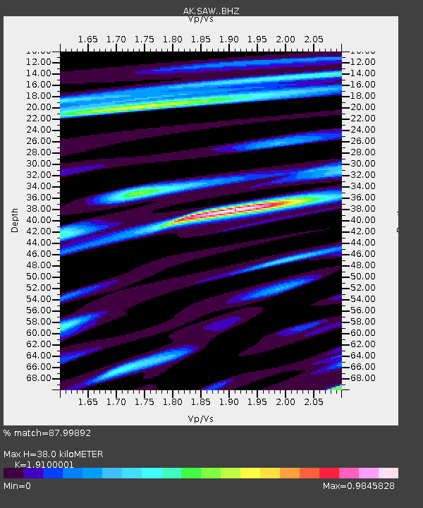
| Estimated Moho Depth: |
38.0 km |
| Estimated Crust Vp/Vs: |
1.91 |
| Assumed Crust Vp: |
6.566 km/s |
| Estimated Crust Vs: |
3.438 km/s |
| Estimated Crust Poisson's Ratio: |
0.31 |
|
| Radial Match: |
87.99892 % |
| Radial Bump: |
400 |
| Transverse Match: |
73.11423 % |
| Transverse Bump: |
400 |
| SOD ConfigId: |
13570011 |
| Insert Time: |
2019-04-28 09:30:16.986 +0000 |
| GWidth: |
2.5 |
| Max Bumps: |
400 |
| Tol: |
0.001 |
|

Signal To Noise
| Channel | StoN | STA | LTA |
| AK:SAW: :BHZ:20170716T17:18:42.847979Z | 7.126127 | 3.158984E-7 | 4.4329607E-8 |
| AK:SAW: :BHN:20170716T17:18:42.847979Z | 3.0049348 | 1.353384E-7 | 4.5038714E-8 |
| AK:SAW: :BHE:20170716T17:18:42.847979Z | 1.4623846 | 6.5463944E-8 | 4.4765205E-8 |
| Arrivals |
| Ps | 5.4 SECOND |
| PpPs | 16 SECOND |
| PsPs/PpSs | 22 SECOND |


