You are here: Home > Network List > CN - Canadian National Seismograph Network Stations List
> Station DAWY Dawson, YT, CA > Earthquake Result Viewer
DAWY Dawson, YT, CA - Earthquake Result Viewer
| Earthquake location: |
Tonga Islands |
| Earthquake latitude/longitude: |
-20.4/-173.5 |
| Earthquake time(UTC): |
2017/07/16 (197) 17:06:41 GMT |
| Earthquake Depth: |
10 km |
| Earthquake Magnitude: |
5.5 Mww |
| Earthquake Catalog/Contributor: |
NEIC PDE/us |
|
| Network: |
CN Canadian National Seismograph Network |
| Station: |
DAWY Dawson, YT, CA |
| Lat/Lon: |
64.06 N/139.39 W |
| Elevation: |
771 m |
|
| Distance: |
88.3 deg |
| Az: |
14.264 deg |
| Baz: |
211.698 deg |
| Ray Param: |
0.042696457 |
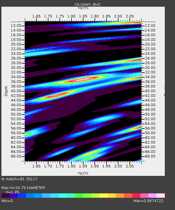
| Estimated Moho Depth: |
34.75 km |
| Estimated Crust Vp/Vs: |
1.85 |
| Assumed Crust Vp: |
6.566 km/s |
| Estimated Crust Vs: |
3.549 km/s |
| Estimated Crust Poisson's Ratio: |
0.29 |
|
| Radial Match: |
91.35117 % |
| Radial Bump: |
400 |
| Transverse Match: |
73.63275 % |
| Transverse Bump: |
400 |
| SOD ConfigId: |
13570011 |
| Insert Time: |
2019-04-28 09:32:24.900 +0000 |
| GWidth: |
2.5 |
| Max Bumps: |
400 |
| Tol: |
0.001 |
|

Signal To Noise
| Channel | StoN | STA | LTA |
| CN:DAWY: :BHZ:20170716T17:19:01.950029Z | 2.3851845 | 1.3339562E-7 | 5.5926744E-8 |
| CN:DAWY: :BHN:20170716T17:19:01.950029Z | 1.1753657 | 5.3440765E-8 | 4.5467353E-8 |
| CN:DAWY: :BHE:20170716T17:19:01.950029Z | 0.5975873 | 2.257139E-8 | 3.7770864E-8 |
| Arrivals |
| Ps | 4.6 SECOND |
| PpPs | 15 SECOND |
| PsPs/PpSs | 19 SECOND |


