You are here: Home > Network List > TA - USArray Transportable Network (new EarthScope stations) Stations List
> Station P30A Selden, KS, USA > Earthquake Result Viewer
P30A Selden, KS, USA - Earthquake Result Viewer
| Earthquake location: |
East Of Severnaya Zemlya |
| Earthquake latitude/longitude: |
81.6/119.5 |
| Earthquake time(UTC): |
2009/10/07 (280) 20:52:13 GMT |
| Earthquake Depth: |
8.0 km |
| Earthquake Magnitude: |
5.7 MB, 5.1 MS, 5.8 MW, 5.8 MW |
| Earthquake Catalog/Contributor: |
WHDF/NEIC |
|
| Network: |
TA USArray Transportable Network (new EarthScope stations) |
| Station: |
P30A Selden, KS, USA |
| Lat/Lon: |
39.54 N/100.25 W |
| Elevation: |
788 m |
|
| Distance: |
57.3 deg |
| Az: |
35.987 deg |
| Baz: |
353.563 deg |
| Ray Param: |
0.06355196 |
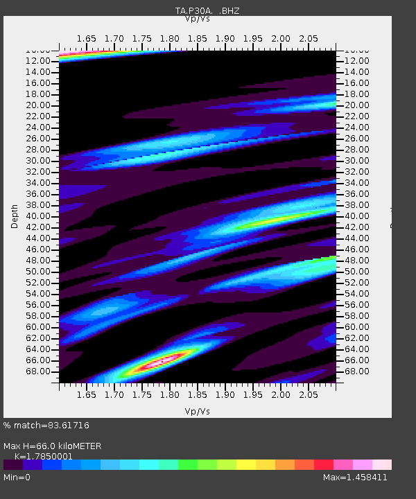
| Estimated Moho Depth: |
66.0 km |
| Estimated Crust Vp/Vs: |
1.79 |
| Assumed Crust Vp: |
6.483 km/s |
| Estimated Crust Vs: |
3.632 km/s |
| Estimated Crust Poisson's Ratio: |
0.27 |
|
| Radial Match: |
83.61716 % |
| Radial Bump: |
400 |
| Transverse Match: |
66.11092 % |
| Transverse Bump: |
400 |
| SOD ConfigId: |
2622 |
| Insert Time: |
2010-03-06 01:53:01.298 +0000 |
| GWidth: |
2.5 |
| Max Bumps: |
400 |
| Tol: |
0.001 |
|
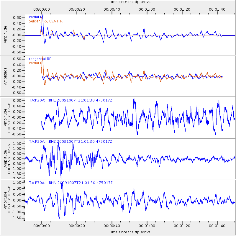
Signal To Noise
| Channel | StoN | STA | LTA |
| TA:P30A: :BHZ:20091007T21:01:30.475017Z | 6.8087316 | 8.0221133E-7 | 1.1782097E-7 |
| TA:P30A: :BHN:20091007T21:01:30.475017Z | 1.9336247 | 3.237458E-7 | 1.674295E-7 |
| TA:P30A: :BHE:20091007T21:01:30.475017Z | 1.2441698 | 2.3928297E-7 | 1.9232338E-7 |
| Arrivals |
| Ps | 8.4 SECOND |
| PpPs | 27 SECOND |
| PsPs/PpSs | 35 SECOND |


