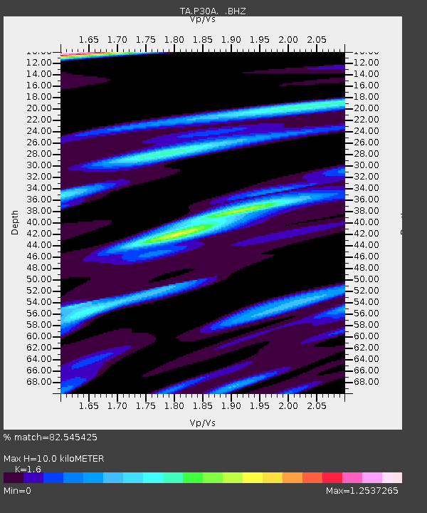
P30A Selden, KS, USA - Earthquake Result Viewer
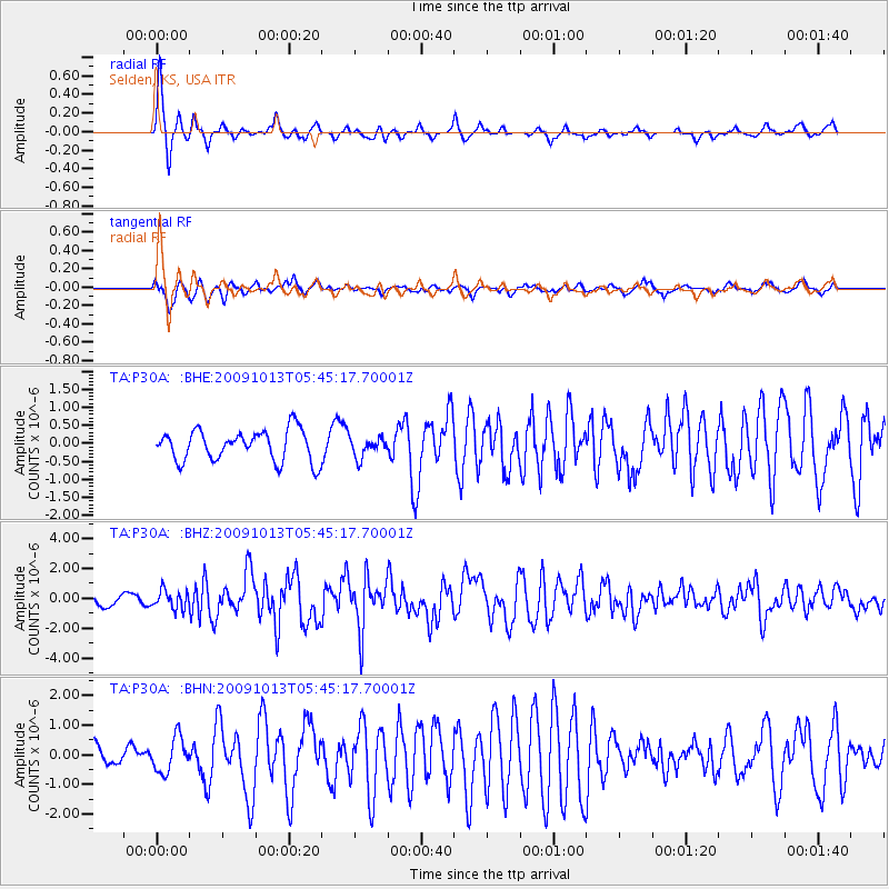
Earthquake location: Fox Islands, Aleutian Islands
Earthquake latitude/longitude: 52.8/-167.0
Earthquake time(UTC): 2009/10/13 (286) 05:37:23 GMT
Earthquake Depth: 24 km
Earthquake Magnitude: 6.0 MB, 6.1 MS, 6.5 MW, 6.5 MW
Earthquake Catalog/Contributor: WHDF/NEIC
Network: TA USArray Transportable Network (new EarthScope stations)
Station: P30A Selden, KS, USA
Lat/Lon: 39.54 N/100.25 W
Elevation: 788 m
Distance: 46.4 deg
Az: 78.615 deg
Baz: 309.592 deg
Ray Param: 0.070604004
Estimated Moho Depth: 10.0 km
Estimated Crust Vp/Vs: 1.60
Assumed Crust Vp: 6.483 km/s
Estimated Crust Vs: 4.052 km/s
Estimated Crust Poisson's Ratio: 0.18
Radial Match: 82.545425 %
Radial Bump: 276
Transverse Match: 71.10498 %
Transverse Bump: 400
SOD ConfigId: 2622
Insert Time: 2010-03-06 01:53:03.132 +0000
GWidth: 2.5
Max Bumps: 400
Tol: 0.001

Signal To Noise

ChannelStoNSTALTA
TA:P30A: :BHZ:20091013T05:45:17.70001Z1.5563396.160521E-73.9583412E-7
TA:P30A: :BHN:20091013T05:45:17.70001Z0.981869165.8861013E-75.994792E-7
TA:P30A: :BHE:20091013T05:45:17.70001Z0.643070942.7514747E-74.2786488E-7
Arrivals
Ps1.0 SECOND
PpPs3.7 SECOND
PsPs/PpSs4.7 SECOND