You are here: Home > Network List > TA - USArray Transportable Network (new EarthScope stations) Stations List
> Station P30A Selden, KS, USA > Earthquake Result Viewer
P30A Selden, KS, USA - Earthquake Result Viewer

| Earthquake location: |
Panama |
| Earthquake latitude/longitude: |
9.6/-79.0 |
| Earthquake time(UTC): |
2009/07/04 (185) 06:49:35 GMT |
| Earthquake Depth: |
38 km |
| Earthquake Magnitude: |
6.0 MB, 5.5 MS, 6.0 MW, 6.0 MW |
| Earthquake Catalog/Contributor: |
WHDF/NEIC |
|
| Network: |
TA USArray Transportable Network (new EarthScope stations) |
| Station: |
P30A Selden, KS, USA |
| Lat/Lon: |
39.54 N/100.25 W |
| Elevation: |
788 m |
|
| Distance: |
35.4 deg |
| Az: |
330.993 deg |
| Baz: |
141.794 deg |
| Ray Param: |
0.07718637 |
| Estimated Moho Depth: |
10.0 km |
| Estimated Crust Vp/Vs: |
1.60 |
| Assumed Crust Vp: |
6.483 km/s |
| Estimated Crust Vs: |
4.052 km/s |
| Estimated Crust Poisson's Ratio: |
0.18 |
|
| Radial Match: |
92.91528 % |
| Radial Bump: |
341 |
| Transverse Match: |
72.96569 % |
| Transverse Bump: |
400 |
| SOD ConfigId: |
2648 |
| Insert Time: |
2010-03-06 01:53:11.774 +0000 |
| GWidth: |
2.5 |
| Max Bumps: |
400 |
| Tol: |
0.001 |
|
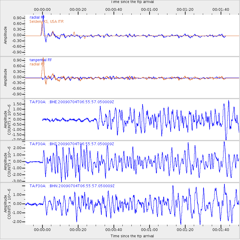
Signal To Noise
| Channel | StoN | STA | LTA |
| TA:P30A: :BHZ:20090704T06:55:57.050009Z | 13.700053 | 8.3827103E-7 | 6.118743E-8 |
| TA:P30A: :BHN:20090704T06:55:57.050009Z | 6.7342973 | 4.7614074E-7 | 7.070385E-8 |
| TA:P30A: :BHE:20090704T06:55:57.050009Z | 7.034369 | 5.347598E-7 | 7.602101E-8 |
| Arrivals |
| Ps | 1.0 SECOND |
| PpPs | 3.7 SECOND |
| PsPs/PpSs | 4.7 SECOND |


