You are here: Home > Network List > MB - Montana Regional Seismic Network Stations List
> Station JTMT Jette Lake, Montana > Earthquake Result Viewer
JTMT Jette Lake, Montana - Earthquake Result Viewer
| Earthquake location: |
Tonga Islands |
| Earthquake latitude/longitude: |
-20.4/-173.5 |
| Earthquake time(UTC): |
2017/07/16 (197) 17:06:41 GMT |
| Earthquake Depth: |
10 km |
| Earthquake Magnitude: |
5.5 Mww |
| Earthquake Catalog/Contributor: |
NEIC PDE/us |
|
| Network: |
MB Montana Regional Seismic Network |
| Station: |
JTMT Jette Lake, Montana |
| Lat/Lon: |
47.75 N/114.28 W |
| Elevation: |
1469 m |
|
| Distance: |
86.1 deg |
| Az: |
35.512 deg |
| Baz: |
233.82 deg |
| Ray Param: |
0.044297993 |
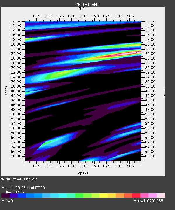
| Estimated Moho Depth: |
23.25 km |
| Estimated Crust Vp/Vs: |
2.08 |
| Assumed Crust Vp: |
6.622 km/s |
| Estimated Crust Vs: |
3.188 km/s |
| Estimated Crust Poisson's Ratio: |
0.35 |
|
| Radial Match: |
83.65696 % |
| Radial Bump: |
400 |
| Transverse Match: |
59.13685 % |
| Transverse Bump: |
400 |
| SOD ConfigId: |
13570011 |
| Insert Time: |
2019-04-28 09:33:36.192 +0000 |
| GWidth: |
2.5 |
| Max Bumps: |
400 |
| Tol: |
0.001 |
|

Signal To Noise
| Channel | StoN | STA | LTA |
| MB:JTMT: :BHZ:20170716T17:18:51.300005Z | 2.9851785 | 1.5757259E-7 | 5.278498E-8 |
| MB:JTMT: :BHN:20170716T17:18:51.300005Z | 0.9791195 | 6.759681E-8 | 6.9038364E-8 |
| MB:JTMT: :BHE:20170716T17:18:51.300005Z | 0.934633 | 7.752042E-8 | 8.2942094E-8 |
| Arrivals |
| Ps | 3.9 SECOND |
| PpPs | 11 SECOND |
| PsPs/PpSs | 14 SECOND |


