You are here: Home > Network List > TA - USArray Transportable Network (new EarthScope stations) Stations List
> Station P30A Selden, KS, USA > Earthquake Result Viewer
P30A Selden, KS, USA - Earthquake Result Viewer
| Earthquake location: |
Baffin Bay |
| Earthquake latitude/longitude: |
75.4/-72.5 |
| Earthquake time(UTC): |
2009/07/07 (188) 19:11:46 GMT |
| Earthquake Depth: |
19 km |
| Earthquake Magnitude: |
5.9 MB, 5.7 MS, 6.1 MW, 6.0 MW |
| Earthquake Catalog/Contributor: |
WHDF/NEIC |
|
| Network: |
TA USArray Transportable Network (new EarthScope stations) |
| Station: |
P30A Selden, KS, USA |
| Lat/Lon: |
39.54 N/100.25 W |
| Elevation: |
788 m |
|
| Distance: |
38.1 deg |
| Az: |
215.789 deg |
| Baz: |
11.097 deg |
| Ray Param: |
0.07575517 |
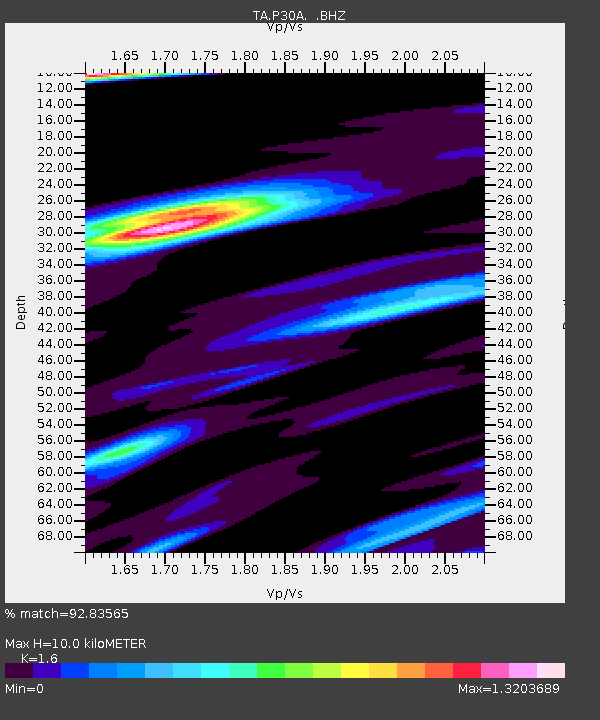
| Estimated Moho Depth: |
10.0 km |
| Estimated Crust Vp/Vs: |
1.60 |
| Assumed Crust Vp: |
6.483 km/s |
| Estimated Crust Vs: |
4.052 km/s |
| Estimated Crust Poisson's Ratio: |
0.18 |
|
| Radial Match: |
92.83565 % |
| Radial Bump: |
285 |
| Transverse Match: |
66.98703 % |
| Transverse Bump: |
400 |
| SOD ConfigId: |
2648 |
| Insert Time: |
2010-03-06 01:53:15.485 +0000 |
| GWidth: |
2.5 |
| Max Bumps: |
400 |
| Tol: |
0.001 |
|
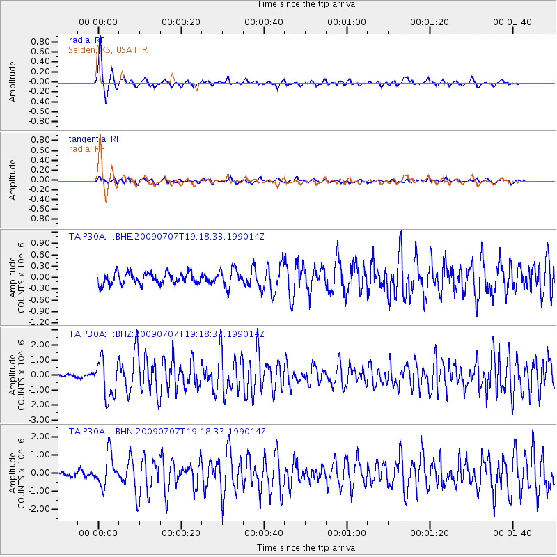
Signal To Noise
| Channel | StoN | STA | LTA |
| TA:P30A: :BHZ:20090707T19:18:33.199014Z | 12.233232 | 1.2649058E-6 | 1.0339915E-7 |
| TA:P30A: :BHN:20090707T19:18:33.199014Z | 6.5750265 | 8.883397E-7 | 1.3510815E-7 |
| TA:P30A: :BHE:20090707T19:18:33.199014Z | 1.5955819 | 2.3949806E-7 | 1.5010077E-7 |
| Arrivals |
| Ps | 1.0 SECOND |
| PpPs | 3.7 SECOND |
| PsPs/PpSs | 4.7 SECOND |


