You are here: Home > Network List > NN - Western Great Basin/Eastern Sierra Nevada Stations List
> Station DSP Deep Springs, California w84gm > Earthquake Result Viewer
DSP Deep Springs, California w84gm - Earthquake Result Viewer
| Earthquake location: |
Tonga Islands |
| Earthquake latitude/longitude: |
-20.4/-173.5 |
| Earthquake time(UTC): |
2017/07/16 (197) 17:06:41 GMT |
| Earthquake Depth: |
10 km |
| Earthquake Magnitude: |
5.5 Mww |
| Earthquake Catalog/Contributor: |
NEIC PDE/us |
|
| Network: |
NN Western Great Basin/Eastern Sierra Nevada |
| Station: |
DSP Deep Springs, California w84gm |
| Lat/Lon: |
37.37 N/117.97 W |
| Elevation: |
1692 m |
|
| Distance: |
77.7 deg |
| Az: |
42.217 deg |
| Baz: |
232.273 deg |
| Ray Param: |
0.050166443 |
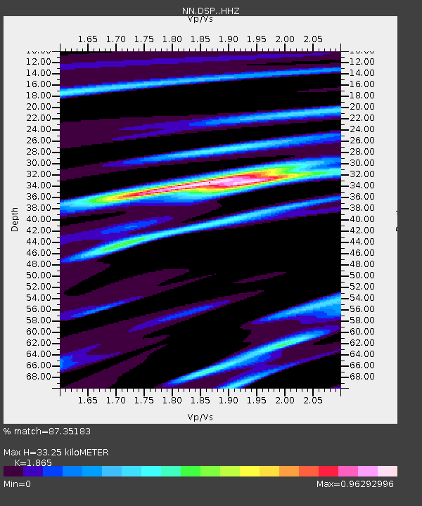
| Estimated Moho Depth: |
33.25 km |
| Estimated Crust Vp/Vs: |
1.87 |
| Assumed Crust Vp: |
6.279 km/s |
| Estimated Crust Vs: |
3.367 km/s |
| Estimated Crust Poisson's Ratio: |
0.30 |
|
| Radial Match: |
87.35183 % |
| Radial Bump: |
293 |
| Transverse Match: |
68.69116 % |
| Transverse Bump: |
400 |
| SOD ConfigId: |
13570011 |
| Insert Time: |
2019-04-28 09:34:01.102 +0000 |
| GWidth: |
2.5 |
| Max Bumps: |
400 |
| Tol: |
0.001 |
|

Signal To Noise
| Channel | StoN | STA | LTA |
| NN:DSP: :HHZ:20170716T17:18:07.117998Z | 0.54562455 | 2.7452414E-8 | 5.031374E-8 |
| NN:DSP: :HHN:20170716T17:18:07.117998Z | 1.0338545 | 7.502413E-8 | 7.25674E-8 |
| NN:DSP: :HHE:20170716T17:18:07.117998Z | 1.3778554 | 8.757149E-8 | 6.355637E-8 |
| Arrivals |
| Ps | 4.7 SECOND |
| PpPs | 15 SECOND |
| PsPs/PpSs | 19 SECOND |


