You are here: Home > Network List > G - GEOSCOPE Stations List
> Station CAN Canberra, Australia > Earthquake Result Viewer
CAN Canberra, Australia - Earthquake Result Viewer
| Earthquake location: |
Talaud Islands, Indonesia |
| Earthquake latitude/longitude: |
3.9/126.9 |
| Earthquake time(UTC): |
2016/01/11 (011) 16:38:07 GMT |
| Earthquake Depth: |
21 km |
| Earthquake Magnitude: |
6.5 MWW, 6.4 MWB, 6.9 MI |
| Earthquake Catalog/Contributor: |
NEIC PDE/NEIC COMCAT |
|
| Network: |
G GEOSCOPE |
| Station: |
CAN Canberra, Australia |
| Lat/Lon: |
35.32 S/149.00 E |
| Elevation: |
650 m |
|
| Distance: |
44.2 deg |
| Az: |
153.759 deg |
| Baz: |
327.353 deg |
| Ray Param: |
0.072053336 |
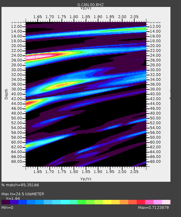
| Estimated Moho Depth: |
24.5 km |
| Estimated Crust Vp/Vs: |
1.64 |
| Assumed Crust Vp: |
6.633 km/s |
| Estimated Crust Vs: |
4.045 km/s |
| Estimated Crust Poisson's Ratio: |
0.20 |
|
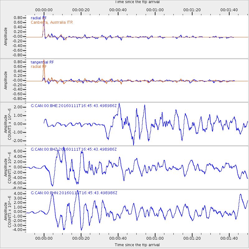
| Radial Match: |
95.35166 % |
| Radial Bump: |
292 |
| Transverse Match: |
81.95038 % |
| Transverse Bump: |
400 |
| SOD ConfigId: |
1399611 |
| Insert Time: |
2016-01-25 16:49:04.994 +0000 |
| GWidth: |
2.5 |
| Max Bumps: |
400 |
| Tol: |
0.001 |
|
Signal To Noise
| Channel | StoN | STA | LTA |
| G:CAN:00:BHZ:20160111T16:45:43.498986Z | 14.493592 | 3.1443565E-6 | 2.1694804E-7 |
| G:CAN:00:BHN:20160111T16:45:43.498986Z | 12.470542 | 1.8165294E-6 | 1.4566564E-7 |
| G:CAN:00:BHE:20160111T16:45:43.498986Z | 4.075273 | 7.6137115E-7 | 1.8682704E-7 |
| Arrivals |
| Ps | 2.6 SECOND |
| PpPs | 9.0 SECOND |
| PsPs/PpSs | 12 SECOND |


