You are here: Home > Network List > TA - USArray Transportable Network (new EarthScope stations) Stations List
> Station D23K Nanushuk River, AK USA > Earthquake Result Viewer
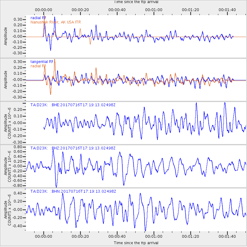
D23K Nanushuk River, AK USA - Earthquake Result Viewer
*The percent match for this event was below the threshold and hence no stack was calculated.
| Earthquake location: |
Tonga Islands |
| Earthquake latitude/longitude: |
-20.4/-173.5 |
| Earthquake time(UTC): |
2017/07/16 (197) 17:06:41 GMT |
| Earthquake Depth: |
10 km |
| Earthquake Magnitude: |
5.5 Mww |
| Earthquake Catalog/Contributor: |
NEIC PDE/us |
|
| Network: |
TA USArray Transportable Network (new EarthScope stations) |
| Station: |
D23K Nanushuk River, AK USA |
| Lat/Lon: |
68.97 N/150.68 W |
| Elevation: |
406 m |
|
| Distance: |
90.7 deg |
| Az: |
8.034 deg |
| Baz: |
201.286 deg |
| Ray Param: |
$rayparam |
*The percent match for this event was below the threshold and hence was not used in the summary stack. |
|
| Radial Match: |
83.684814 % |
| Radial Bump: |
400 |
| Transverse Match: |
72.07122 % |
| Transverse Bump: |
400 |
| SOD ConfigId: |
13570011 |
| Insert Time: |
2019-04-28 09:35:19.982 +0000 |
| GWidth: |
2.5 |
| Max Bumps: |
400 |
| Tol: |
0.001 |
|
Signal To Noise
| Channel | StoN | STA | LTA |
| TA:D23K: :BHZ:20170716T17:19:13.02498Z | 1.1387789 | 1.2304412E-7 | 1.0804916E-7 |
| TA:D23K: :BHN:20170716T17:19:13.02498Z | 0.7922534 | 5.067982E-8 | 6.39692E-8 |
| TA:D23K: :BHE:20170716T17:19:13.02498Z | 0.95723975 | 5.5935967E-8 | 5.8434644E-8 |
| Arrivals |
| Ps | |
| PpPs | |
| PsPs/PpSs | |


