You are here: Home > Network List > TA - USArray Transportable Network (new EarthScope stations) Stations List
> Station P30A Selden, KS, USA > Earthquake Result Viewer
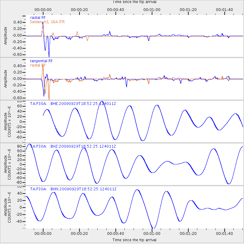
P30A Selden, KS, USA - Earthquake Result Viewer
*The percent match for this event was below the threshold and hence no stack was calculated.
| Earthquake location: |
Tonga Islands |
| Earthquake latitude/longitude: |
-15.4/-173.2 |
| Earthquake time(UTC): |
2009/09/29 (272) 18:40:09 GMT |
| Earthquake Depth: |
2.3 km |
| Earthquake Magnitude: |
5.5 MB |
| Earthquake Catalog/Contributor: |
WHDF/NEIC |
|
| Network: |
TA USArray Transportable Network (new EarthScope stations) |
| Station: |
P30A Selden, KS, USA |
| Lat/Lon: |
39.54 N/100.25 W |
| Elevation: |
788 m |
|
| Distance: |
87.1 deg |
| Az: |
47.764 deg |
| Baz: |
247.483 deg |
| Ray Param: |
$rayparam |
*The percent match for this event was below the threshold and hence was not used in the summary stack. |
|
| Radial Match: |
88.52847 % |
| Radial Bump: |
400 |
| Transverse Match: |
85.42708 % |
| Transverse Bump: |
282 |
| SOD ConfigId: |
2622 |
| Insert Time: |
2010-03-06 01:53:22.408 +0000 |
| GWidth: |
2.5 |
| Max Bumps: |
400 |
| Tol: |
0.001 |
|
Signal To Noise
| Channel | StoN | STA | LTA |
| TA:P30A: :BHZ:20090929T18:52:25.124011Z | 0.85223305 | 5.8149177E-5 | 6.8231544E-5 |
| TA:P30A: :BHN:20090929T18:52:25.124011Z | 0.99566364 | 2.560649E-5 | 2.5718013E-5 |
| TA:P30A: :BHE:20090929T18:52:25.124011Z | 1.5901757 | 6.1715655E-5 | 3.881059E-5 |
| Arrivals |
| Ps | |
| PpPs | |
| PsPs/PpSs | |


