You are here: Home > Network List > TA - USArray Transportable Network (new EarthScope stations) Stations List
> Station G18K Tagagawik, AK, USA > Earthquake Result Viewer
G18K Tagagawik, AK, USA - Earthquake Result Viewer
| Earthquake location: |
Tonga Islands |
| Earthquake latitude/longitude: |
-20.4/-173.5 |
| Earthquake time(UTC): |
2017/07/16 (197) 17:06:41 GMT |
| Earthquake Depth: |
10 km |
| Earthquake Magnitude: |
5.5 Mww |
| Earthquake Catalog/Contributor: |
NEIC PDE/us |
|
| Network: |
TA USArray Transportable Network (new EarthScope stations) |
| Station: |
G18K Tagagawik, AK, USA |
| Lat/Lon: |
65.89 N/158.65 W |
| Elevation: |
484 m |
|
| Distance: |
86.8 deg |
| Az: |
6.031 deg |
| Baz: |
193.881 deg |
| Ray Param: |
0.043788444 |
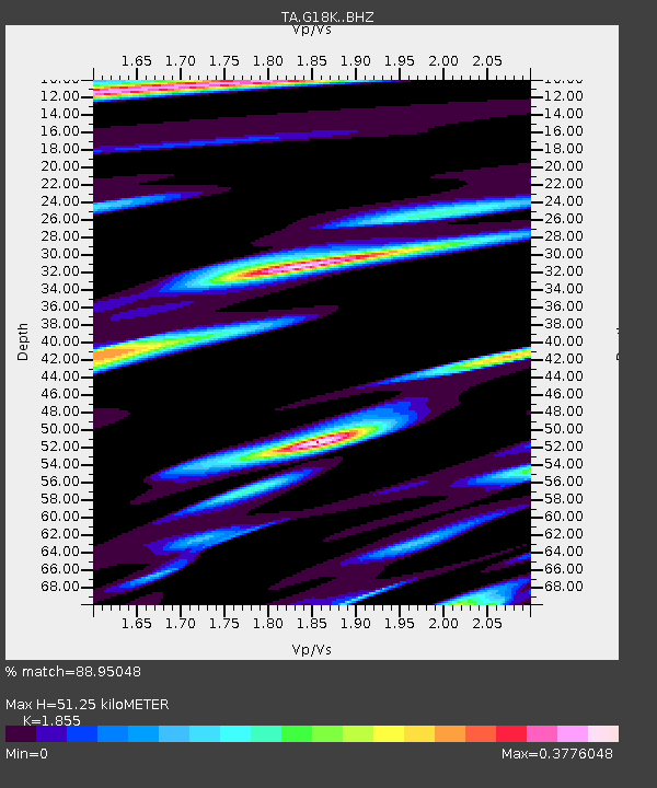
| Estimated Moho Depth: |
51.25 km |
| Estimated Crust Vp/Vs: |
1.86 |
| Assumed Crust Vp: |
6.1 km/s |
| Estimated Crust Vs: |
3.288 km/s |
| Estimated Crust Poisson's Ratio: |
0.30 |
|
| Radial Match: |
88.95048 % |
| Radial Bump: |
347 |
| Transverse Match: |
89.06733 % |
| Transverse Bump: |
400 |
| SOD ConfigId: |
13570011 |
| Insert Time: |
2019-04-28 09:35:29.843 +0000 |
| GWidth: |
2.5 |
| Max Bumps: |
400 |
| Tol: |
0.001 |
|

Signal To Noise
| Channel | StoN | STA | LTA |
| TA:G18K: :BHZ:20170716T17:18:54.800005Z | 9.210521 | 3.6498741E-7 | 3.962723E-8 |
| TA:G18K: :BHN:20170716T17:18:54.800005Z | 2.7355568 | 1.0133626E-7 | 3.704411E-8 |
| TA:G18K: :BHE:20170716T17:18:54.800005Z | 1.5191572 | 4.9844605E-8 | 3.2810696E-8 |
| Arrivals |
| Ps | 7.3 SECOND |
| PpPs | 24 SECOND |
| PsPs/PpSs | 31 SECOND |


