You are here: Home > Network List > TA - USArray Transportable Network (new EarthScope stations) Stations List
> Station G30M túh Zraii Njik, YT, CAN > Earthquake Result Viewer
G30M túh Zraii Njik, YT, CAN - Earthquake Result Viewer
| Earthquake location: |
Tonga Islands |
| Earthquake latitude/longitude: |
-20.4/-173.5 |
| Earthquake time(UTC): |
2017/07/16 (197) 17:06:41 GMT |
| Earthquake Depth: |
10 km |
| Earthquake Magnitude: |
5.5 Mww |
| Earthquake Catalog/Contributor: |
NEIC PDE/us |
|
| Network: |
TA USArray Transportable Network (new EarthScope stations) |
| Station: |
G30M túh Zraii Njik, YT, CAN |
| Lat/Lon: |
66.98 N/136.22 W |
| Elevation: |
739 m |
|
| Distance: |
91.5 deg |
| Az: |
13.77 deg |
| Baz: |
214.582 deg |
| Ray Param: |
0.041600168 |
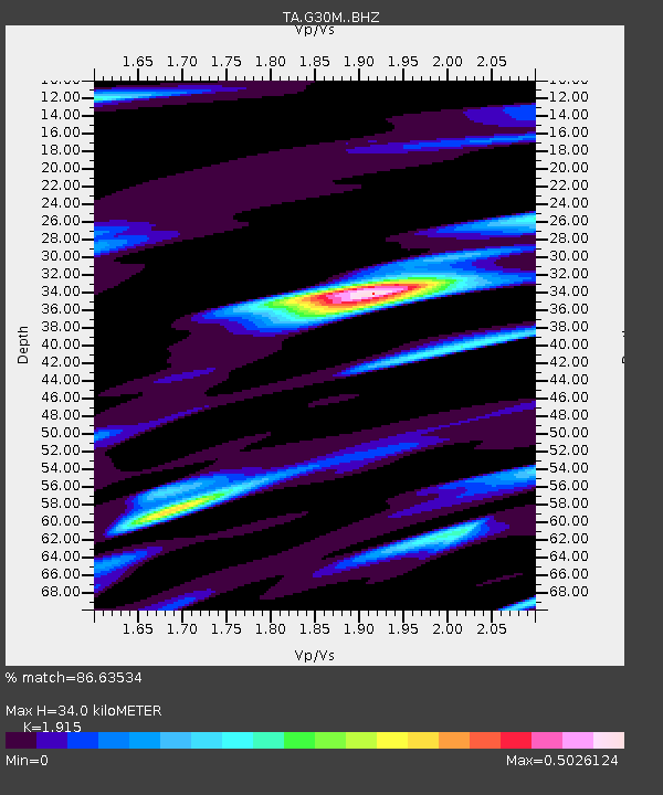
| Estimated Moho Depth: |
34.0 km |
| Estimated Crust Vp/Vs: |
1.91 |
| Assumed Crust Vp: |
6.522 km/s |
| Estimated Crust Vs: |
3.406 km/s |
| Estimated Crust Poisson's Ratio: |
0.31 |
|
| Radial Match: |
86.63534 % |
| Radial Bump: |
400 |
| Transverse Match: |
79.04931 % |
| Transverse Bump: |
400 |
| SOD ConfigId: |
13570011 |
| Insert Time: |
2019-04-28 09:35:37.454 +0000 |
| GWidth: |
2.5 |
| Max Bumps: |
400 |
| Tol: |
0.001 |
|

Signal To Noise
| Channel | StoN | STA | LTA |
| TA:G30M: :BHZ:20170716T17:19:16.724993Z | 3.542546 | 2.460766E-7 | 6.946321E-8 |
| TA:G30M: :BHN:20170716T17:19:16.724993Z | 1.0330619 | 5.6022515E-8 | 5.4229584E-8 |
| TA:G30M: :BHE:20170716T17:19:16.724993Z | 1.6499996 | 7.131445E-8 | 4.322089E-8 |
| Arrivals |
| Ps | 4.9 SECOND |
| PpPs | 15 SECOND |
| PsPs/PpSs | 20 SECOND |


