You are here: Home > Network List > TA - USArray Transportable Network (new EarthScope stations) Stations List
> Station I17K Unalakleet, AK, USA > Earthquake Result Viewer
I17K Unalakleet, AK, USA - Earthquake Result Viewer
| Earthquake location: |
Tonga Islands |
| Earthquake latitude/longitude: |
-20.4/-173.5 |
| Earthquake time(UTC): |
2017/07/16 (197) 17:06:41 GMT |
| Earthquake Depth: |
10 km |
| Earthquake Magnitude: |
5.5 Mww |
| Earthquake Catalog/Contributor: |
NEIC PDE/us |
|
| Network: |
TA USArray Transportable Network (new EarthScope stations) |
| Station: |
I17K Unalakleet, AK, USA |
| Lat/Lon: |
63.89 N/160.70 W |
| Elevation: |
105 m |
|
| Distance: |
84.6 deg |
| Az: |
5.633 deg |
| Baz: |
192.005 deg |
| Ray Param: |
0.045339044 |
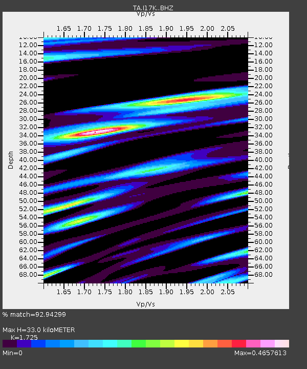
| Estimated Moho Depth: |
33.0 km |
| Estimated Crust Vp/Vs: |
1.73 |
| Assumed Crust Vp: |
6.276 km/s |
| Estimated Crust Vs: |
3.638 km/s |
| Estimated Crust Poisson's Ratio: |
0.25 |
|
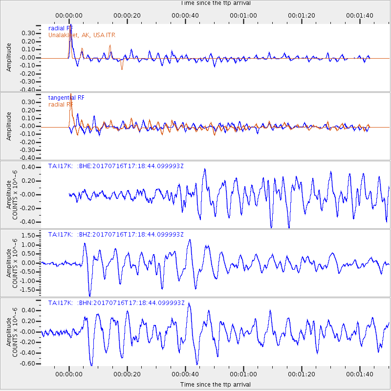
| Radial Match: |
92.94299 % |
| Radial Bump: |
400 |
| Transverse Match: |
89.51962 % |
| Transverse Bump: |
400 |
| SOD ConfigId: |
13570011 |
| Insert Time: |
2019-04-28 09:35:46.299 +0000 |
| GWidth: |
2.5 |
| Max Bumps: |
400 |
| Tol: |
0.001 |
|
Signal To Noise
| Channel | StoN | STA | LTA |
| TA:I17K: :BHZ:20170716T17:18:44.099993Z | 1.7973778 | 9.350341E-8 | 5.2022123E-8 |
| TA:I17K: :BHN:20170716T17:18:44.099993Z | 1.1122445 | 5.2943008E-8 | 4.7600153E-8 |
| TA:I17K: :BHE:20170716T17:18:44.099993Z | 1.4308776 | 5.8207142E-8 | 4.0679332E-8 |
| Arrivals |
| Ps | 3.9 SECOND |
| PpPs | 14 SECOND |
| PsPs/PpSs | 18 SECOND |


