You are here: Home > Network List > TA - USArray Transportable Network (new EarthScope stations) Stations List
> Station K15K Wolf Creek Mountain, AK, USA > Earthquake Result Viewer
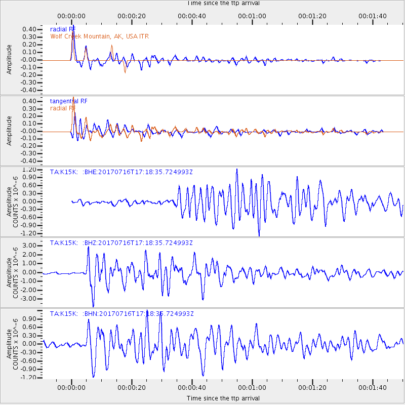
K15K Wolf Creek Mountain, AK, USA - Earthquake Result Viewer
| Earthquake location: |
Tonga Islands |
| Earthquake latitude/longitude: |
-20.4/-173.5 |
| Earthquake time(UTC): |
2017/07/16 (197) 17:06:41 GMT |
| Earthquake Depth: |
10 km |
| Earthquake Magnitude: |
5.5 Mww |
| Earthquake Catalog/Contributor: |
NEIC PDE/us |
|
| Network: |
TA USArray Transportable Network (new EarthScope stations) |
| Station: |
K15K Wolf Creek Mountain, AK, USA |
| Lat/Lon: |
62.29 N/161.53 W |
| Elevation: |
346 m |
|
| Distance: |
83.0 deg |
| Az: |
5.583 deg |
| Baz: |
191.256 deg |
| Ray Param: |
0.04649971 |
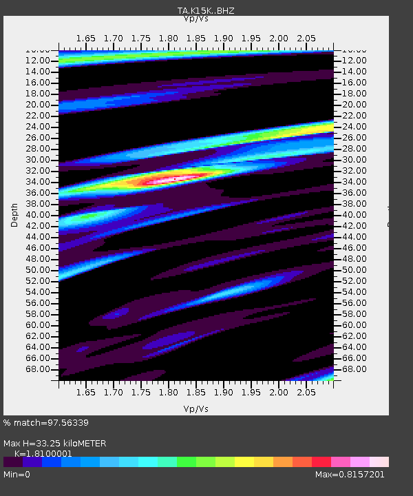
| Estimated Moho Depth: |
33.25 km |
| Estimated Crust Vp/Vs: |
1.81 |
| Assumed Crust Vp: |
6.276 km/s |
| Estimated Crust Vs: |
3.467 km/s |
| Estimated Crust Poisson's Ratio: |
0.28 |
|
| Radial Match: |
97.56339 % |
| Radial Bump: |
266 |
| Transverse Match: |
96.037186 % |
| Transverse Bump: |
349 |
| SOD ConfigId: |
13570011 |
| Insert Time: |
2019-04-28 09:35:59.852 +0000 |
| GWidth: |
2.5 |
| Max Bumps: |
400 |
| Tol: |
0.001 |
|
Signal To Noise
| Channel | StoN | STA | LTA |
| TA:K15K: :BHZ:20170716T17:18:35.724993Z | 0.8982048 | 5.6825712E-8 | 6.326587E-8 |
| TA:K15K: :BHN:20170716T17:18:35.724993Z | 0.8451631 | 4.2342986E-8 | 5.010037E-8 |
| TA:K15K: :BHE:20170716T17:18:35.724993Z | 0.8569518 | 5.11077E-8 | 5.963895E-8 |
| Arrivals |
| Ps | 4.4 SECOND |
| PpPs | 15 SECOND |
| PsPs/PpSs | 19 SECOND |


