You are here: Home > Network List > TA - USArray Transportable Network (new EarthScope stations) Stations List
> Station K29M Barlow Dome, YT, CAN > Earthquake Result Viewer
K29M Barlow Dome, YT, CAN - Earthquake Result Viewer
| Earthquake location: |
Tonga Islands |
| Earthquake latitude/longitude: |
-20.4/-173.5 |
| Earthquake time(UTC): |
2017/07/16 (197) 17:06:41 GMT |
| Earthquake Depth: |
10 km |
| Earthquake Magnitude: |
5.5 Mww |
| Earthquake Catalog/Contributor: |
NEIC PDE/us |
|
| Network: |
TA USArray Transportable Network (new EarthScope stations) |
| Station: |
K29M Barlow Dome, YT, CAN |
| Lat/Lon: |
63.84 N/137.52 W |
| Elevation: |
1367 m |
|
| Distance: |
88.5 deg |
| Az: |
15.081 deg |
| Baz: |
213.402 deg |
| Ray Param: |
0.04250492 |
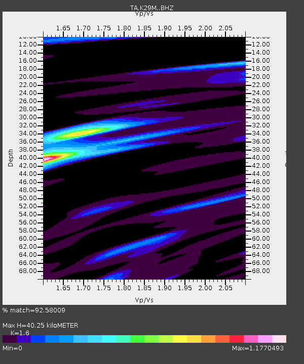
| Estimated Moho Depth: |
40.25 km |
| Estimated Crust Vp/Vs: |
1.60 |
| Assumed Crust Vp: |
6.566 km/s |
| Estimated Crust Vs: |
4.104 km/s |
| Estimated Crust Poisson's Ratio: |
0.18 |
|
| Radial Match: |
92.58009 % |
| Radial Bump: |
309 |
| Transverse Match: |
73.42904 % |
| Transverse Bump: |
400 |
| SOD ConfigId: |
13570011 |
| Insert Time: |
2019-04-28 09:36:05.017 +0000 |
| GWidth: |
2.5 |
| Max Bumps: |
400 |
| Tol: |
0.001 |
|
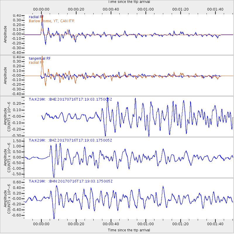
Signal To Noise
| Channel | StoN | STA | LTA |
| TA:K29M: :BHZ:20170716T17:19:03.175005Z | 1.8875252 | 1.0588367E-7 | 5.609656E-8 |
| TA:K29M: :BHN:20170716T17:19:03.175005Z | 1.3166125 | 5.4193247E-8 | 4.1161123E-8 |
| TA:K29M: :BHE:20170716T17:19:03.175005Z | 1.0404644 | 3.537604E-8 | 3.400024E-8 |
| Arrivals |
| Ps | 3.8 SECOND |
| PpPs | 16 SECOND |
| PsPs/PpSs | 19 SECOND |


