You are here: Home > Network List > TA - USArray Transportable Network (new EarthScope stations) Stations List
> Station Q31A Ellis, KS, USA > Earthquake Result Viewer
Q31A Ellis, KS, USA - Earthquake Result Viewer

| Earthquake location: |
Near S. Coast Of Honshu, Japan |
| Earthquake latitude/longitude: |
33.2/137.9 |
| Earthquake time(UTC): |
2009/08/09 (221) 10:55:55 GMT |
| Earthquake Depth: |
297 km |
| Earthquake Magnitude: |
6.5 MB, 7.1 MW, 7.1 MW |
| Earthquake Catalog/Contributor: |
WHDF/NEIC |
|
| Network: |
TA USArray Transportable Network (new EarthScope stations) |
| Station: |
Q31A Ellis, KS, USA |
| Lat/Lon: |
39.00 N/99.39 W |
| Elevation: |
680 m |
|
| Distance: |
90.7 deg |
| Az: |
40.994 deg |
| Baz: |
315.077 deg |
| Ray Param: |
0.041581765 |
| Estimated Moho Depth: |
30.75 km |
| Estimated Crust Vp/Vs: |
1.88 |
| Assumed Crust Vp: |
6.483 km/s |
| Estimated Crust Vs: |
3.439 km/s |
| Estimated Crust Poisson's Ratio: |
0.30 |
|
| Radial Match: |
92.37107 % |
| Radial Bump: |
400 |
| Transverse Match: |
64.24867 % |
| Transverse Bump: |
400 |
| SOD ConfigId: |
2622 |
| Insert Time: |
2010-03-06 01:53:38.353 +0000 |
| GWidth: |
2.5 |
| Max Bumps: |
400 |
| Tol: |
0.001 |
|
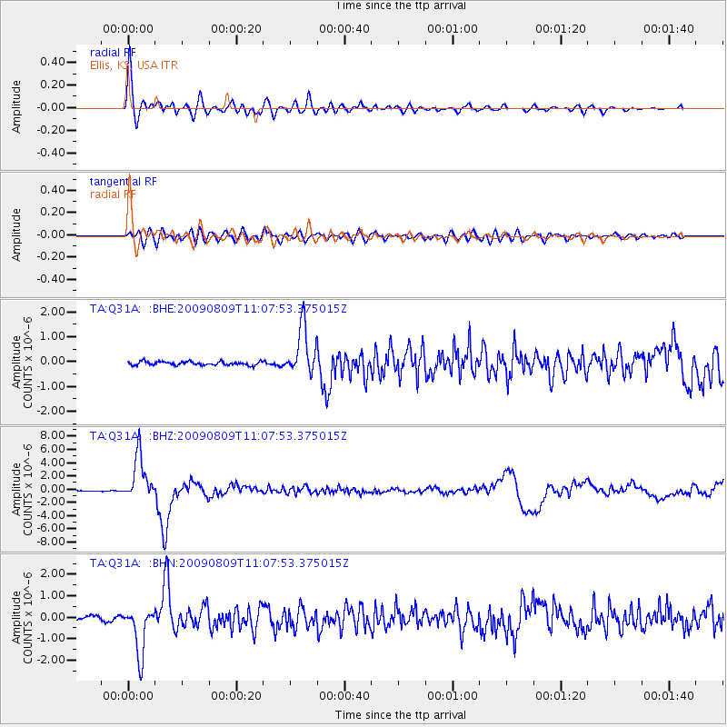
Signal To Noise
| Channel | StoN | STA | LTA |
| TA:Q31A: :BHZ:20090809T11:07:53.375015Z | 42.702946 | 3.4369377E-6 | 8.0484796E-8 |
| TA:Q31A: :BHN:20090809T11:07:53.375015Z | 10.995528 | 1.1284635E-6 | 1.02629315E-7 |
| TA:Q31A: :BHE:20090809T11:07:53.375015Z | 13.569961 | 9.767066E-7 | 7.197564E-8 |
| Arrivals |
| Ps | 4.3 SECOND |
| PpPs | 13 SECOND |
| PsPs/PpSs | 18 SECOND |


