You are here: Home > Network List > TA - USArray Transportable Network (new EarthScope stations) Stations List
> Station P23K Montague Island, AK, USA > Earthquake Result Viewer
P23K Montague Island, AK, USA - Earthquake Result Viewer
| Earthquake location: |
Tonga Islands |
| Earthquake latitude/longitude: |
-20.4/-173.5 |
| Earthquake time(UTC): |
2017/07/16 (197) 17:06:41 GMT |
| Earthquake Depth: |
10 km |
| Earthquake Magnitude: |
5.5 Mww |
| Earthquake Catalog/Contributor: |
NEIC PDE/us |
|
| Network: |
TA USArray Transportable Network (new EarthScope stations) |
| Station: |
P23K Montague Island, AK, USA |
| Lat/Lon: |
60.00 N/147.40 W |
| Elevation: |
287 m |
|
| Distance: |
82.9 deg |
| Az: |
12.85 deg |
| Baz: |
204.519 deg |
| Ray Param: |
0.046552937 |
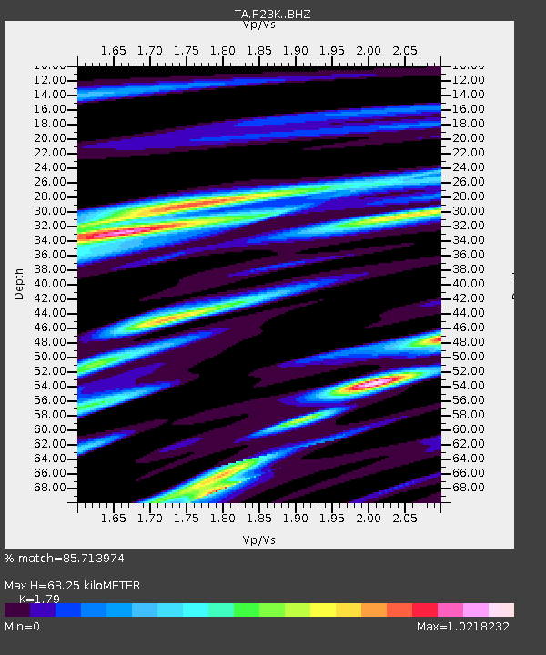
| Estimated Moho Depth: |
68.25 km |
| Estimated Crust Vp/Vs: |
1.79 |
| Assumed Crust Vp: |
5.989 km/s |
| Estimated Crust Vs: |
3.346 km/s |
| Estimated Crust Poisson's Ratio: |
0.27 |
|
| Radial Match: |
85.713974 % |
| Radial Bump: |
400 |
| Transverse Match: |
77.67366 % |
| Transverse Bump: |
400 |
| SOD ConfigId: |
13570011 |
| Insert Time: |
2019-04-28 09:36:44.726 +0000 |
| GWidth: |
2.5 |
| Max Bumps: |
400 |
| Tol: |
0.001 |
|

Signal To Noise
| Channel | StoN | STA | LTA |
| TA:P23K: :BHZ:20170716T17:18:35.325029Z | 3.3999655 | 2.842031E-7 | 8.3589995E-8 |
| TA:P23K: :BHN:20170716T17:18:35.325029Z | 1.2396754 | 9.539621E-8 | 7.6952574E-8 |
| TA:P23K: :BHE:20170716T17:18:35.325029Z | 1.0396376 | 9.366704E-8 | 9.009587E-8 |
| Arrivals |
| Ps | 9.2 SECOND |
| PpPs | 31 SECOND |
| PsPs/PpSs | 40 SECOND |


