You are here: Home > Network List > TA - USArray Transportable Network (new EarthScope stations) Stations List
> Station Q17K Contact Creek, Katmai, AK, USA > Earthquake Result Viewer
Q17K Contact Creek, Katmai, AK, USA - Earthquake Result Viewer
| Earthquake location: |
Tonga Islands |
| Earthquake latitude/longitude: |
-20.4/-173.5 |
| Earthquake time(UTC): |
2017/07/16 (197) 17:06:41 GMT |
| Earthquake Depth: |
10 km |
| Earthquake Magnitude: |
5.5 Mww |
| Earthquake Catalog/Contributor: |
NEIC PDE/us |
|
| Network: |
TA USArray Transportable Network (new EarthScope stations) |
| Station: |
Q17K Contact Creek, Katmai, AK, USA |
| Lat/Lon: |
58.26 N/155.89 W |
| Elevation: |
1165 m |
|
| Distance: |
79.8 deg |
| Az: |
9.329 deg |
| Baz: |
196.716 deg |
| Ray Param: |
0.04874373 |
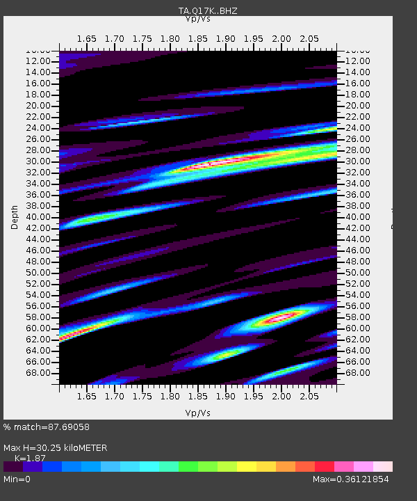
| Estimated Moho Depth: |
30.25 km |
| Estimated Crust Vp/Vs: |
1.87 |
| Assumed Crust Vp: |
6.438 km/s |
| Estimated Crust Vs: |
3.443 km/s |
| Estimated Crust Poisson's Ratio: |
0.30 |
|
| Radial Match: |
87.69058 % |
| Radial Bump: |
400 |
| Transverse Match: |
80.04064 % |
| Transverse Bump: |
400 |
| SOD ConfigId: |
13570011 |
| Insert Time: |
2019-04-28 09:36:48.908 +0000 |
| GWidth: |
2.5 |
| Max Bumps: |
400 |
| Tol: |
0.001 |
|

Signal To Noise
| Channel | StoN | STA | LTA |
| TA:Q17K: :BHZ:20170716T17:18:18.599993Z | 2.9090137 | 4.2359795E-7 | 1.4561566E-7 |
| TA:Q17K: :BHN:20170716T17:18:18.599993Z | 2.2984223 | 1.3365161E-7 | 5.8149283E-8 |
| TA:Q17K: :BHE:20170716T17:18:18.599993Z | 1.0382591 | 6.613861E-8 | 6.370145E-8 |
| Arrivals |
| Ps | 4.2 SECOND |
| PpPs | 13 SECOND |
| PsPs/PpSs | 17 SECOND |


