You are here: Home > Network List > TA - USArray Transportable Network (new EarthScope stations) Stations List
> Station Q24A Divide, CO, USA > Earthquake Result Viewer
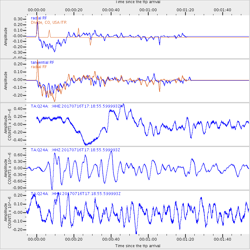
Q24A Divide, CO, USA - Earthquake Result Viewer
*The percent match for this event was below the threshold and hence no stack was calculated.
| Earthquake location: |
Tonga Islands |
| Earthquake latitude/longitude: |
-20.4/-173.5 |
| Earthquake time(UTC): |
2017/07/16 (197) 17:06:41 GMT |
| Earthquake Depth: |
10 km |
| Earthquake Magnitude: |
5.5 Mww |
| Earthquake Catalog/Contributor: |
NEIC PDE/us |
|
| Network: |
TA USArray Transportable Network (new EarthScope stations) |
| Station: |
Q24A Divide, CO, USA |
| Lat/Lon: |
38.96 N/105.15 W |
| Elevation: |
2775 m |
|
| Distance: |
87.0 deg |
| Az: |
46.501 deg |
| Baz: |
240.76 deg |
| Ray Param: |
$rayparam |
*The percent match for this event was below the threshold and hence was not used in the summary stack. |
|
| Radial Match: |
29.798227 % |
| Radial Bump: |
400 |
| Transverse Match: |
16.553085 % |
| Transverse Bump: |
400 |
| SOD ConfigId: |
13570011 |
| Insert Time: |
2019-04-28 09:36:50.944 +0000 |
| GWidth: |
2.5 |
| Max Bumps: |
400 |
| Tol: |
0.001 |
|
Signal To Noise
| Channel | StoN | STA | LTA |
| TA:Q24A: :HHZ:20170716T17:18:55.599993Z | 1.4235308 | 6.9104985E-8 | 4.8544777E-8 |
| TA:Q24A: :HHN:20170716T17:18:55.599993Z | 2.3452332 | 1.1547116E-7 | 4.9236537E-8 |
| TA:Q24A: :HHE:20170716T17:18:55.599993Z | 3.4856722 | 4.5719946E-7 | 1.3116536E-7 |
| Arrivals |
| Ps | |
| PpPs | |
| PsPs/PpSs | |


