You are here: Home > Network List > TA - USArray Transportable Network (new EarthScope stations) Stations List
> Station V35K Ketchikan, AK, USA > Earthquake Result Viewer
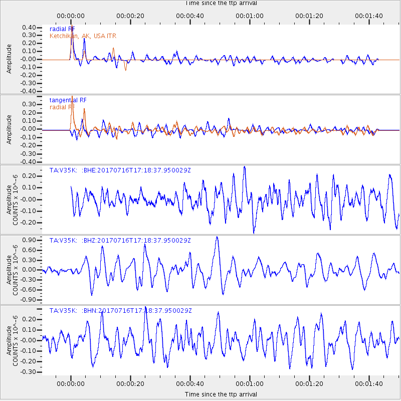
V35K Ketchikan, AK, USA - Earthquake Result Viewer
*The percent match for this event was below the threshold and hence no stack was calculated.
| Earthquake location: |
Tonga Islands |
| Earthquake latitude/longitude: |
-20.4/-173.5 |
| Earthquake time(UTC): |
2017/07/16 (197) 17:06:41 GMT |
| Earthquake Depth: |
10 km |
| Earthquake Magnitude: |
5.5 Mww |
| Earthquake Catalog/Contributor: |
NEIC PDE/us |
|
| Network: |
TA USArray Transportable Network (new EarthScope stations) |
| Station: |
V35K Ketchikan, AK, USA |
| Lat/Lon: |
55.33 N/131.62 W |
| Elevation: |
64 m |
|
| Distance: |
83.4 deg |
| Az: |
22.563 deg |
| Baz: |
219.026 deg |
| Ray Param: |
$rayparam |
*The percent match for this event was below the threshold and hence was not used in the summary stack. |
|
| Radial Match: |
77.7052 % |
| Radial Bump: |
400 |
| Transverse Match: |
76.47725 % |
| Transverse Bump: |
400 |
| SOD ConfigId: |
13570011 |
| Insert Time: |
2019-04-28 09:37:00.241 +0000 |
| GWidth: |
2.5 |
| Max Bumps: |
400 |
| Tol: |
0.001 |
|
Signal To Noise
| Channel | StoN | STA | LTA |
| TA:V35K: :BHZ:20170716T17:18:37.950029Z | 1.5925766 | 1.2385635E-7 | 7.777105E-8 |
| TA:V35K: :BHN:20170716T17:18:37.950029Z | 1.5523949 | 6.7718545E-8 | 4.3621984E-8 |
| TA:V35K: :BHE:20170716T17:18:37.950029Z | 0.50436974 | 3.0627923E-8 | 6.072514E-8 |
| Arrivals |
| Ps | |
| PpPs | |
| PsPs/PpSs | |


