You are here: Home > Network List > TA - USArray Transportable Network (new EarthScope stations) Stations List
> Station Q31A Ellis, KS, USA > Earthquake Result Viewer
Q31A Ellis, KS, USA - Earthquake Result Viewer
| Earthquake location: |
West Chile Rise |
| Earthquake latitude/longitude: |
-41.7/-84.0 |
| Earthquake time(UTC): |
2009/06/10 (161) 23:13:21 GMT |
| Earthquake Depth: |
10 km |
| Earthquake Magnitude: |
5.7 MB, 5.2 MS, 5.7 MW, 5.6 MW |
| Earthquake Catalog/Contributor: |
WHDF/NEIC |
|
| Network: |
TA USArray Transportable Network (new EarthScope stations) |
| Station: |
Q31A Ellis, KS, USA |
| Lat/Lon: |
39.00 N/99.39 W |
| Elevation: |
680 m |
|
| Distance: |
81.6 deg |
| Az: |
347.926 deg |
| Baz: |
168.405 deg |
| Ray Param: |
0.047503155 |
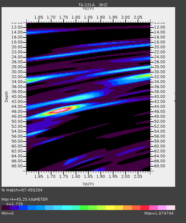
| Estimated Moho Depth: |
45.25 km |
| Estimated Crust Vp/Vs: |
1.74 |
| Assumed Crust Vp: |
6.483 km/s |
| Estimated Crust Vs: |
3.736 km/s |
| Estimated Crust Poisson's Ratio: |
0.25 |
|
| Radial Match: |
87.455284 % |
| Radial Bump: |
400 |
| Transverse Match: |
75.23432 % |
| Transverse Bump: |
400 |
| SOD ConfigId: |
2648 |
| Insert Time: |
2010-03-06 01:53:53.810 +0000 |
| GWidth: |
2.5 |
| Max Bumps: |
400 |
| Tol: |
0.001 |
|

Signal To Noise
| Channel | StoN | STA | LTA |
| TA:Q31A: :BHZ:20090610T23:25:07.400007Z | 6.108283 | 4.7334817E-7 | 7.7492835E-8 |
| TA:Q31A: :BHN:20090610T23:25:07.400007Z | 4.249681 | 2.5901895E-7 | 6.095021E-8 |
| TA:Q31A: :BHE:20090610T23:25:07.400007Z | 1.6640059 | 1.0551301E-7 | 6.340903E-8 |
| Arrivals |
| Ps | 5.3 SECOND |
| PpPs | 19 SECOND |
| PsPs/PpSs | 24 SECOND |


