You are here: Home > Network List > X416 - Monitoring Active Faults for Tectonic Mapping Efforts in Washington State Stations List
> Station MA08 Snohomish County, WA, USA > Earthquake Result Viewer
MA08 Snohomish County, WA, USA - Earthquake Result Viewer
| Earthquake location: |
Tonga Islands |
| Earthquake latitude/longitude: |
-20.4/-173.5 |
| Earthquake time(UTC): |
2017/07/16 (197) 17:06:41 GMT |
| Earthquake Depth: |
10 km |
| Earthquake Magnitude: |
5.5 Mww |
| Earthquake Catalog/Contributor: |
NEIC PDE/us |
|
| Network: |
X4 Monitoring Active Faults for Tectonic Mapping Efforts in Washington State |
| Station: |
MA08 Snohomish County, WA, USA |
| Lat/Lon: |
47.78 N/121.82 W |
| Elevation: |
-1.0 m |
|
| Distance: |
82.2 deg |
| Az: |
32.262 deg |
| Baz: |
227.918 deg |
| Ray Param: |
0.0470763 |
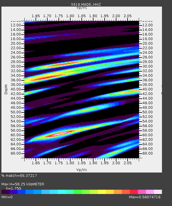
| Estimated Moho Depth: |
59.25 km |
| Estimated Crust Vp/Vs: |
1.75 |
| Assumed Crust Vp: |
6.597 km/s |
| Estimated Crust Vs: |
3.759 km/s |
| Estimated Crust Poisson's Ratio: |
0.26 |
|
| Radial Match: |
88.37217 % |
| Radial Bump: |
400 |
| Transverse Match: |
69.79605 % |
| Transverse Bump: |
400 |
| SOD ConfigId: |
13570011 |
| Insert Time: |
2019-04-28 09:37:59.175 +0000 |
| GWidth: |
2.5 |
| Max Bumps: |
400 |
| Tol: |
0.001 |
|

Signal To Noise
| Channel | StoN | STA | LTA |
| X4:MA08: :HHZ:20170716T17:18:31.385027Z | 2.0848987 | 8.902683E-8 | 4.270079E-8 |
| X4:MA08: :HHN:20170716T17:18:31.385027Z | 2.2627313 | 1.3084231E-7 | 5.7824938E-8 |
| X4:MA08: :HHE:20170716T17:18:31.385027Z | 0.75049794 | 5.560209E-8 | 7.4086934E-8 |
| Arrivals |
| Ps | 7.0 SECOND |
| PpPs | 24 SECOND |
| PsPs/PpSs | 31 SECOND |


