You are here: Home > Network List > TA - USArray Transportable Network (new EarthScope stations) Stations List
> Station Q31A Ellis, KS, USA > Earthquake Result Viewer
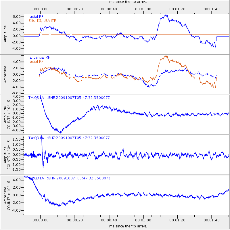
Q31A Ellis, KS, USA - Earthquake Result Viewer
*The percent match for this event was below the threshold and hence no stack was calculated.
| Earthquake location: |
Rat Islands, Aleutian Islands |
| Earthquake latitude/longitude: |
52.2/178.1 |
| Earthquake time(UTC): |
2009/10/07 (280) 05:38:37 GMT |
| Earthquake Depth: |
138 km |
| Earthquake Magnitude: |
5.6 MB, 5.6 MW, 5.6 MW |
| Earthquake Catalog/Contributor: |
WHDF/NEIC |
|
| Network: |
TA USArray Transportable Network (new EarthScope stations) |
| Station: |
Q31A Ellis, KS, USA |
| Lat/Lon: |
39.00 N/99.39 W |
| Elevation: |
680 m |
|
| Distance: |
56.2 deg |
| Az: |
68.353 deg |
| Baz: |
312.699 deg |
| Ray Param: |
$rayparam |
*The percent match for this event was below the threshold and hence was not used in the summary stack. |
|
| Radial Match: |
31.557386 % |
| Radial Bump: |
400 |
| Transverse Match: |
27.161655 % |
| Transverse Bump: |
400 |
| SOD ConfigId: |
2622 |
| Insert Time: |
2010-03-06 01:54:19.682 +0000 |
| GWidth: |
2.5 |
| Max Bumps: |
400 |
| Tol: |
0.001 |
|
Signal To Noise
| Channel | StoN | STA | LTA |
| TA:Q31A: :BHZ:20091007T05:47:32.350007Z | 3.708645 | 6.49338E-7 | 1.7508768E-7 |
| TA:Q31A: :BHN:20091007T05:47:32.350007Z | 0.27920386 | 1.6529059E-6 | 5.9200684E-6 |
| TA:Q31A: :BHE:20091007T05:47:32.350007Z | 1.7515414 | 3.312205E-6 | 1.8910231E-6 |
| Arrivals |
| Ps | |
| PpPs | |
| PsPs/PpSs | |


