You are here: Home > Network List > AK - Alaska Regional Network Stations List
> Station TRF Thorofare Mountian, AK, USA > Earthquake Result Viewer
TRF Thorofare Mountian, AK, USA - Earthquake Result Viewer
| Earthquake location: |
Tonga Islands |
| Earthquake latitude/longitude: |
-20.4/-173.3 |
| Earthquake time(UTC): |
2017/07/17 (198) 01:20:32 GMT |
| Earthquake Depth: |
10 km |
| Earthquake Magnitude: |
5.6 Mww |
| Earthquake Catalog/Contributor: |
NEIC PDE/us |
|
| Network: |
AK Alaska Regional Network |
| Station: |
TRF Thorofare Mountian, AK, USA |
| Lat/Lon: |
63.45 N/150.29 W |
| Elevation: |
1710 m |
|
| Distance: |
85.5 deg |
| Az: |
10.158 deg |
| Baz: |
201.602 deg |
| Ray Param: |
0.04472149 |
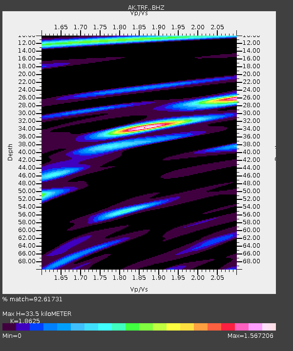
| Estimated Moho Depth: |
33.5 km |
| Estimated Crust Vp/Vs: |
1.86 |
| Assumed Crust Vp: |
6.438 km/s |
| Estimated Crust Vs: |
3.457 km/s |
| Estimated Crust Poisson's Ratio: |
0.30 |
|
| Radial Match: |
92.61731 % |
| Radial Bump: |
397 |
| Transverse Match: |
85.20038 % |
| Transverse Bump: |
400 |
| SOD ConfigId: |
13570011 |
| Insert Time: |
2019-04-28 09:39:13.103 +0000 |
| GWidth: |
2.5 |
| Max Bumps: |
400 |
| Tol: |
0.001 |
|

Signal To Noise
| Channel | StoN | STA | LTA |
| AK:TRF: :BHZ:20170717T01:32:39.088008Z | 3.2624316 | 1.4736007E-7 | 4.5168782E-8 |
| AK:TRF: :BHN:20170717T01:32:39.088008Z | 0.93428725 | 5.640325E-8 | 6.0370354E-8 |
| AK:TRF: :BHE:20170717T01:32:39.088008Z | 0.83465487 | 4.673028E-8 | 5.5987545E-8 |
| Arrivals |
| Ps | 4.6 SECOND |
| PpPs | 15 SECOND |
| PsPs/PpSs | 19 SECOND |


