You are here: Home > Network List > TA - USArray Transportable Network (new EarthScope stations) Stations List
> Station M30A Dale-Ortello Valley, Anselmo, NE, USA > Earthquake Result Viewer
M30A Dale-Ortello Valley, Anselmo, NE, USA - Earthquake Result Viewer
| Earthquake location: |
Near S. Coast Of Honshu, Japan |
| Earthquake latitude/longitude: |
33.2/137.9 |
| Earthquake time(UTC): |
2009/08/09 (221) 10:55:55 GMT |
| Earthquake Depth: |
297 km |
| Earthquake Magnitude: |
6.5 MB, 7.1 MW, 7.1 MW |
| Earthquake Catalog/Contributor: |
WHDF/NEIC |
|
| Network: |
TA USArray Transportable Network (new EarthScope stations) |
| Station: |
M30A Dale-Ortello Valley, Anselmo, NE, USA |
| Lat/Lon: |
41.54 N/99.87 W |
| Elevation: |
853 m |
|
| Distance: |
88.6 deg |
| Az: |
39.46 deg |
| Baz: |
314.76 deg |
| Ray Param: |
0.041744962 |
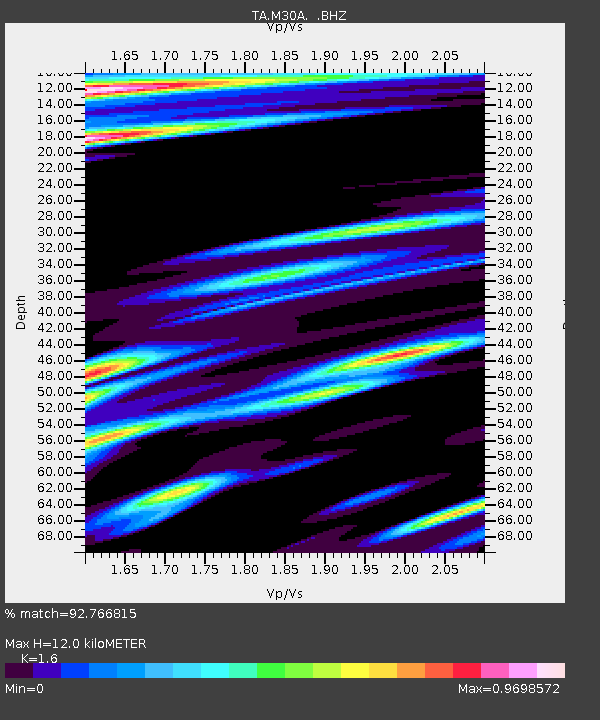
| Estimated Moho Depth: |
12.0 km |
| Estimated Crust Vp/Vs: |
1.60 |
| Assumed Crust Vp: |
6.53 km/s |
| Estimated Crust Vs: |
4.082 km/s |
| Estimated Crust Poisson's Ratio: |
0.18 |
|
| Radial Match: |
92.766815 % |
| Radial Bump: |
400 |
| Transverse Match: |
79.15751 % |
| Transverse Bump: |
400 |
| SOD ConfigId: |
2622 |
| Insert Time: |
2010-03-06 01:54:45.380 +0000 |
| GWidth: |
2.5 |
| Max Bumps: |
400 |
| Tol: |
0.001 |
|
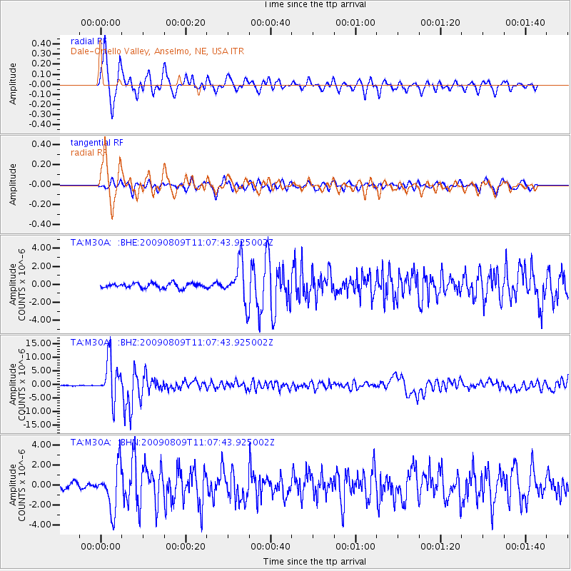
Signal To Noise
| Channel | StoN | STA | LTA |
| TA:M30A: :BHZ:20090809T11:07:43.925002Z | 74.13453 | 7.5822927E-6 | 1.02277475E-7 |
| TA:M30A: :BHN:20090809T11:07:43.925002Z | 10.728872 | 2.2521613E-6 | 2.0991595E-7 |
| TA:M30A: :BHE:20090809T11:07:43.925002Z | 8.464917 | 2.2925713E-6 | 2.708321E-7 |
| Arrivals |
| Ps | 1.1 SECOND |
| PpPs | 4.7 SECOND |
| PsPs/PpSs | 5.8 SECOND |


