You are here: Home > Network List > TA - USArray Transportable Network (new EarthScope stations) Stations List
> Station F21K Alatna River, AK, USA > Earthquake Result Viewer
F21K Alatna River, AK, USA - Earthquake Result Viewer

| Earthquake location: |
Tonga Islands |
| Earthquake latitude/longitude: |
-20.4/-173.3 |
| Earthquake time(UTC): |
2017/07/17 (198) 01:20:32 GMT |
| Earthquake Depth: |
10 km |
| Earthquake Magnitude: |
5.6 Mww |
| Earthquake Catalog/Contributor: |
NEIC PDE/us |
|
| Network: |
TA USArray Transportable Network (new EarthScope stations) |
| Station: |
F21K Alatna River, AK, USA |
| Lat/Lon: |
67.22 N/153.48 W |
| Elevation: |
597 m |
|
| Distance: |
88.6 deg |
| Az: |
7.596 deg |
| Baz: |
198.569 deg |
| Ray Param: |
0.042470004 |
| Estimated Moho Depth: |
63.75 km |
| Estimated Crust Vp/Vs: |
1.87 |
| Assumed Crust Vp: |
6.455 km/s |
| Estimated Crust Vs: |
3.457 km/s |
| Estimated Crust Poisson's Ratio: |
0.30 |
|
| Radial Match: |
81.029854 % |
| Radial Bump: |
400 |
| Transverse Match: |
76.627625 % |
| Transverse Bump: |
400 |
| SOD ConfigId: |
13570011 |
| Insert Time: |
2019-04-28 09:43:40.062 +0000 |
| GWidth: |
2.5 |
| Max Bumps: |
400 |
| Tol: |
0.001 |
|
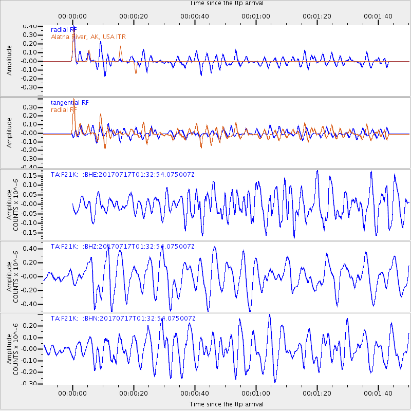
Signal To Noise
| Channel | StoN | STA | LTA |
| TA:F21K: :BHZ:20170717T01:32:54.075007Z | 1.8205191 | 8.715996E-8 | 4.7876437E-8 |
| TA:F21K: :BHN:20170717T01:32:54.075007Z | 1.5940732 | 4.7534755E-8 | 2.9819684E-8 |
| TA:F21K: :BHE:20170717T01:32:54.075007Z | 1.2916026 | 4.607478E-8 | 3.5672567E-8 |
| Arrivals |
| Ps | 8.7 SECOND |
| PpPs | 28 SECOND |
| PsPs/PpSs | 36 SECOND |


